Cody, Wyoming
Cody, Wyoming
Yellowstone Region: East Entrance
Explore spectacular folded mountain ranges and one of Earth's biggest prehistoric landslides!
Why Explore Cody?
In addition to being one of the best "Old West" towns, Cody is surrounded by spectacular geology and natural beauty. You'll see one of Earth's largest prehistoric landslides, spectacularly folded mountain ranges, one of North America's biggest volcanic fields (and no, it's not Yellowstone!), the Great Unconformity, and breath-taking scenery in every direction. It's close to Yellowstone, the Beartooth Mountains and its famous scenic highway, and the Absaroka Wilderness, making this a good trip to combine with others. I'll have additional field trips to each of those places posted soon.Travel to Cody
Location: Cody is located on U.S. Highway 20 east of Yellowstone National Park. In fact, to enter Yellowstone from the east, you have to go through Cody.Time:
Lodging: Lodging is abundant and affordable in Cody.
Restaurants: Cody has a surprising number of good restaurants!
Vehicle: Any. The road to Clark Fork is steep.
Seasons: Spring, Summer, Fall. Cody is the gateway to snow machine tours into Yellowstone and surrounding areas during the winter.
Other Attractions: Buffalo Bill Historical Center is a first-class museum of art and western history. Buffalo Bill's own Irma Hotel and restaurant & saloon is the old west come alive. Sierra Trading Post has an outlet story in Cody.
Logistics: Cody has a Wal-Mart Supercenter for resupply. Don't miss the Buffalo Bill Dam visitor center! Admission is free.
Geology of the Cody Area, Wyoming
1. Heart Mountain Detachment
This landslide is so big, it isn't even referred to as a landslide, it's called a "detachment." It's one of those few geologic features that are so big and mind-boggling, they weren't generally accepted as real for decades (like the glacial Lake Missoula floods).
The landslide's vital statistics are impressive:
Covers 500 square miles (1300 square km)
Displacement of 25 miles (40 km)
Thickness of 4-5 km
Speed may have been 100 mph
Its origins are still debated a bit, especially in the details of mechanisms for sliding, but the basic story is this: Between 50 and 48 million years ago, the Beartooth Mountains were just finished being uplifted. At the same time, the Absaroka volcanic field began experiencing gigantic eruptions. On the uplift, the stack of sedimentary rock layers about 4-5 km thick began to slide southward and southeastward into what was then a big flat basin (the Bighorn Basin to the east and the Absaroka Basin to the south). The sliding sheet broke into sections as it slid, and some blocks were tilted. Some argue that the block may have slid catastrphically and very rapidly, at perhaps 100 miles per hour. What made the sliding surface so slippery? Models suggest hot water, high water pressure, or even high gas pressure along the surface. Whatever the case may be, the sliding mass put old Paleozoic rocks on top of the young basin sediments at places like Heart Mountain and Buffalo Bill Reservoir. Closer to the Beartooth Mountains, the oldest rocks are still on top of Paleozoic sedimentary rocks. We'll look at all of those.
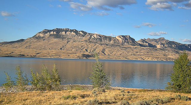
(Above) Sheep Mountain on the south side of Buffalo Bill reservoir is the southernmost part of the Heart Mountain detachment block. The rocks on top are Mississippian limestone, and the lower lumpy slopes are late Cretaceous to Eocene sedimentary rocks. The detachment is just below the cliffs. The Mississippian rocks slid out onto the Absaroka basin, covering the sediments below.
(Above) A wider view of the Sheep Mountain detachment block. The detachment is at the base of the cliffs. It's easy to spot the basin-fill sediments that were buried by the landslide because they are relatively soft and form gentle slopes and landslides.
(Above) Sunrise on Sheep Mountain from the North Fork campground.
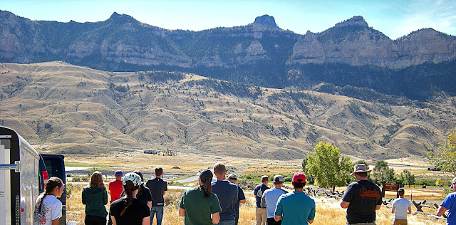
(Above) Some of the hundreds of Geology students who try to understand the Heart Mountain Detachment every year. It's a great educational tool because it seems to break a lot of geologic "rules" that Freshmen learn.
(Above) The detached peaks north of the North Fork campground are part of the giant landslide. The detachment is at the base of the cliffs. Note how some of the blocks are separated from each other and are slightly tilted.
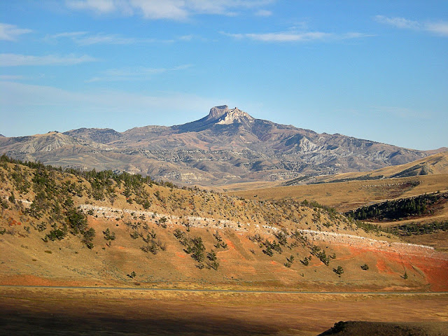
(Above) Heart Mountain, the slide's namesake, is north of Cody. For decades it was mapped as a thrust fault because it puts older rocks on top of younger, and it was only after painstaking regional work and investigation that its real nature as a landslide remnant became apparent. More recent uplift of the Rocky Mountains region has caused the rivers and streams to erode down into the Bighorn and other basins, leaving the 48 million year old ground surface and landslide on high peaks like this one.
The following locations are north of Cody. Take highway 120 north of town (the turnoff in town is easy to miss -- refer to the map). The turnoff looks like this northbound on 16th Street / Hwy 14:
You'll drive by good views of Heart Mountain. About 16 miles north of Cody, turn left on the Chief Joseph Highway (Wyoming 296) toward Yellowstone and the Beartooth Mountains.
Clark Canyon
(Above) This southward view is on the Chief Joseph Highway looking back to the north end of Rattlesnake Mountain and Cody. The red rocks are the Triassic Chugwater formation, one of my favorite rock names. It was formed in a shallow inland sea during the early dinosaur age 200-250 million years ago.
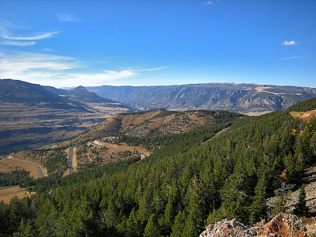
(Above) View from the summit on Chief Joseph Highway. The flat-topped mountain on the right side is the Beartooth Mountains, the source of the Heart Mountain detachment. The canyon to the left is the Sunlight basin. While you're at the view area, be sure to read the signs about this road's interesting history.
(Above) From the view area you'll look down on this block. Looking carefully, you'll see the triangular flat surface on the right side of it. That is the Heart Mtn Detachment, with the rocks above eroded off. The detachment continues to the left below the faulted and tilted rocks above. Here, the detached blocks are still on top of Paleozoic sedimentary rocks, having not reached the Bighorn Basin.
(Above) In this wide view from the view area, the detached block above is on the left and the Beartooth Mountains are on the right. The horizontal lines on the far mountain slopes are glacial moraines from the peak of the last ice age. The ice was a thousand feet thick, and flowed from the Sunlight area on the left to Clark Fork on the right.
(Above) Also from the highway view area, you can see Table Mountain, which is the Heart Mountain detachment with the rocks above eroded off. The massive mountains behind are the Beartooth Mountains, the source of the giant landslide.
(Above) View of the Absaroka Wilderness from the highway view area. The snow-covered peaks are all volcanic rocks about 50 million years old, part of one of the largest volcanic fields in North American geologic history.
(Above) If you continue toward Yellowstone on the Chief Joseph Highway, you'll come to the Beartooth Highway, U.S. 212. This is a southward view from the small pullout that has an outhouse. The Heart Mountain detachment is the horizontal surface running all the way across this view. In places it has sedimentary rocks on top of it, and in others those rocks separated and Absaroka volcanic rocks were deposited directly on the detachment surface. I love bringing curious travelers here and seeing if they can figure out what they're looking at! Now you have a head start.
The Great Unconformity
An unconformity is a boundary across which time is missing from the geologic record. In other words, there is a gap in time between the rocks above and below. An angular unconformity is a boundary in which the rocks below are tilted more than the rocks above, which means the boundary represents a time during which tectonic tilting or folding took place before the lower rocks were eroded down to a flat surface and the rocks above were deposited. The "Great Unconformity" is the boundary with Precambrian rocks below and Paleozoic rocks above. Here in western Wyoming, the time missing across that boundary is about 2 Billion years, or half of Earth's entire history! It's also present in the Grand Canyon and many locations across North America, with varying amounts of time missing.
(Above) This unconformity is present under all of Cody. It is between the 200 million year old Chugwater formation and Tertiary sediments less than about 10 million years old. Viewpoint is a highway 20 turnout west of the Cody Rodeo Grounds.
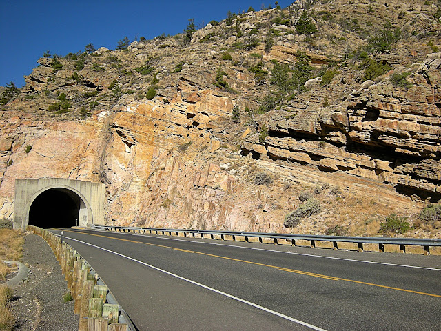
(Above) The Great Unconformity is the tilted surface between the layered sandstone above the tunnel and the pinkish granite below. Half of Earth's history is missing across that boundary! This is highway 20 west of Cody just east of the Buffalo Bill dam.
(Above) Here, the Great Unconformity has a stream channel. The sandstone above is called the Cambrian Flathead Sandstone, and it contains pieces of the older granite in it. The sandstone was deposited after a sustained period of tectonic inactivity and erosion, as the ocean advanced across the continent from west to east. Imagine that -- North America was eroded all the way down to sea level at the end of the Precambrian era about 540 million years ago!

(Above) Close-up of weathered granite below the Flathead sandstone. The granite was weathered (dissolved and broken up) when it was at the ground surface 540 million years ago.
Folded Mountains
(Above) The next set of geologic features that will dazzle you at Cody are the folded mountains, especially Rattlesnake Mountain and the eastern Beartooth Mountains. These formed between about 70 and 50 million years ago during what geologists call the "Laramide orogeny" (orogeny means a mountain-building event). During tectonic plate collisions between North America and the ancestors of the Pacific plate, thick blocks of crust were uplifted from northern New Mexico through Colorado and Wyoming to southernmost Montana. The uplift occurred along thrust faults that dip about 30-45 degrees deep into the crust. The uplifted block is typically folded into an asymmetric anticline on its forward edge as you'll see at Buffalo Bill dam and the eastern Beartooth uplift.
(Above) The highway 20 tunnel at Buffalo Bill dam goes through the center of the Rattlesnake Mountain asymmetric anticline. The rocks are Archean granite, over 2 billion years old.
(Above) In this downstream view from the Buffalo Bill dam you can see that the rock layers are tilted away from you. The near cliffs are Archean granite, and the far cliffs are Paleozoic sedimentary rocks above the Great Unconformity. This is the center of the fold.
(Above) The Buffalo Bill dam was built in 1910, and at 325 feet (99 m) was the tallest in the world at the time. You can see water seeping out of fractures in the granite, but don't worry - it's an extremely solid foundation for a dam.
(Above) Top of the Buffalo Bill dam and the visitor center.
(Above) From the dam you can also see one section of the highway 20 tunnel.
(Above) View of the anticline at the dam on Cedar Mountain. Follow any layer from the top left to the lower right, and you'll see that it goes through a steep section and then flattens out just a bit toward the right. That's what we mean by an "asymmetric" fold - the two limbs are different lengths and geometries. The limb on the Cody (east) side is long and gently dipping.
(Above) From Buffalo Bill Reservoir you can look northward along Rattlesnake Mountain and see the steep part of the anticline. The rock layers in the center of this view are nearly vertical, forming rounded triangular slabs pointing up into the sky. The rocks on the skyline dip away from the viewer.
The pictures below were taken at the mouth of Clark Fork just west of Clark, Wyoming. From Cody, take highway 120 north (see directions above) about 32 miles to Clark. At Clark, turn left at the signs for Clark Fork access (brown signs). The turn is at a place called Edelweiss House and a green sign to "Clark." Take this road all the way to the dead end in the mouth of the big canyon.
Through Clark you'll pass an odd landscape littered with boulders. They were carried from the Beartooth Mountains and dropped there by the enormous Clark Fork glacier that melted away about 12,000 years ago.

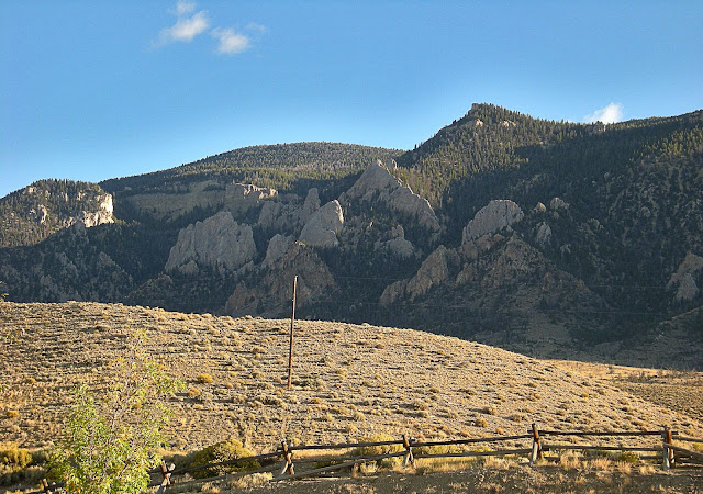
(Above) Approaching Clark Fork canyon, you'll pass these inconspicuously interesting ridges between the bedrock hills. They are glacial moraines, piles of gravel carried here by a glacier. The great fold is at the canyon mouth ahead.
(Above) The easternmost part of the fold was made of soft, easily erodible rocks that have long since washed away. Only the most hard, resistant rocks remain.

(Above) The red Triassic Chugwater formation is easy to spot throughout western Wyoming. Here, it was folded into a steep wall on the steep forelimb of the Beartooth anticline.
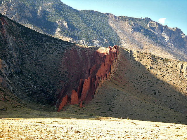
(Above) Closeup of the Chugwater.
(Above) View from near the end of the road to the south. The fold progresses from gently dipping at the upper right to nearly vertical at the left. Deep under this mountain front is a "blind" thrust fault at the core of the fold (called "blind" because it doesn't cut all the way through to the surface). None of these faults are thought to be capable of earthquakes because this area's tectonic activity has ceased. But we can hope, can't we?
(Above) Closer view of the fold. The lumpy lower slopes are just piles of rock fallen from above and deposited by the glacier.
Related Posts: Yellowstone or Wyoming labels, and companion trips to the Beartooth Mountains and Clark Fork canyon.
M.S. - More Science
More about the Laramide Orogeny in Wyoming
More about the Heart Mountain Detachment
More about the Bighorn Basin
More about the Absaroka Volcanics


