Calaveras Fault at Hollister, California
Calaveras Fault at Hollister, California

Why Visit Hollister?
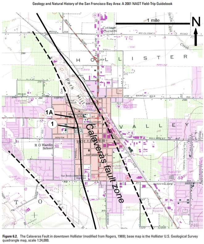
Hollister is a quaint, friendly, enjoyable town in farm country, and a pleasant day trip from the Bay Area, Monterey, or the Central Valley. It also happens to sit astride one of the plate boundary faults, the Calaveras, which is slowly but surely tearing the town in half.The Calaveras fault here is unusual because it creeps, moving a few millimeters per year, instead of storing up energy and releasing it all in a big earthquake. Small quakes do occur here, but not large-displacement earthquakes. That makes it a favorite laboratory for Earth Scientists and students to see faulting in slow-motion. It's a kind of "Faults For Dummies!"
The creep rate has varied from year to year between 6 and 12 mm/year (1/4 to 1/2 inch per year). The doesn't sound like much until you add it up over your lifetime. If you live 80 years, you'll see the sidewalks and streets in Hollister move by 480 mm to 960 mm (20 to 40 inches). When it's your street or your house, that's a lot!
Like the Bay Area, many homes and structures in Hollister were damaged by earthquakes on the San Andreas in 1906 and 1989.
(Map) Hollister is SE of the San Francisco Bay Area. Start your visit at Dunne Park, bordered by 6th and 7th, West and Powell streets. Powell changes name to Locust north of 4th Street.
Travel to Hollister, California
What To See: Roads, sidewalks, and houses are being displaced along the fault.Difficulty: Easy. Accessible to all. About 5 blocks walking round-trip.
Time: 1-2 hours will do it, depending on how many details you stop to see and how good your picnic is.
Logistics: A picnic on the fault in Dunne Park makes for a nice day! Hollister also has a lot of good places to eat. Combine this trip with a visit to the old Spanish mission at San Juan Bautista, which sits right next to the San Andreas fault.
Cautions: Please be careful crossing busy 4th Street.
Courtesy: Please respect the private homes you'll be near. Stay off of yards and walks! Refrain from being intrusive with cameras -- I've provided photos here and in the links below so you don't have to take pictures. You can also see them on Google Street View. The residents are very familiar with the fault and all the field trips that come to gawk at their houses, and while some are bothered by the notoriety, I've also had pleasant conversations with some folks sitting on their porches. But please be respectful of their privacy, especially if you are with a group -- please keep the noise down and the cameras discreet.
I think you'll like Hollister. A long-time friend of mine has lived there all his life and wouldn't trade it for any place. I once had a flat tire on a van, and getting a new tire at San Benito Tire Pros was so pleasant it didn't seem like a problem at all. I recommend a walk around the old downtown on San Benito Street for its simple charm.

Geology of the Calaveras Fault
The Calaveras is a branch of the San Andreas tectonic plate boundary. It splits off from the San Andreas several miles south of the valley. The west side is sliding northwestward with the Pacific Plate, but is still part of the North American plate.The fault is thought to creep in this area because of the types of rocks and minerals deep in the fault zone. Alteration of rocks and minerals at depth forms a host of slippery minerals that don't allow stress to build up to high levels.

Tour of the Calaveras Fault
Begin at Dunne Park. The slight drop in the park is the trace of the Calaveras fault.


Once you've reached Park Hill, your tour is over! Time for that picnic in the park!
<end of tour>
Related Trips: Those with the San Andreas label.
B.S. -- Common Misconceptions
California cannot "fall into the ocean." In fact, the coastal mountains are slowly rising higher above sea level. You can see the evidence in the terraces along the central and northern coast that are old beach levels, now lifted high above the waves.
M.S. -- More Science
A walking tour guide from Stanford.
Visit http://scedc.caltech.edu/recent/index.html to see recent earthquakes in California and Nevada, and browse their other pages for lots more information.
USGS field guide to faulting in the Hollister area.
Good summary of the San Andreas: http://pubs.usgs.gov/gip/earthq3/
Better in-depth document: http://pubs.er.usgs.gov/publication/pp1515
Better in-depth document: http://pubs.er.usgs.gov/publication/pp1515
You can also do a web search like this: "san andreas" site:usgs.gov

