Banff Part 2
Banff National Park, part 2
This place will exhaust your vocabulary!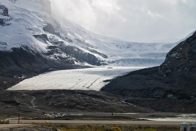
Banff - One of the World's Most Beautiful Places
(Above) Castle Mountain is between Banff and Lake Louise along Highway 1. It is made of Precambrian and Cambrian quartzite, limestone, and a little shale of (from bottom to top) the Mount Whyte, Cathedral, Stephen, Eldon, Pika, and Arctomys Formations. These rocks were thrust eastward over younger sedimentary rocks. They were deposited in the ocean tens of km farther west, and shoved up and over coastal rocks during collisions between the North American plate and islands and volcanic mountains on the subducting ancestor of the Pacific plate. This mountain looks a little different from others in the area because the rocks are not as steeply tilted and they are made mostly of sandstone, where many other peaks are made of gray limestone.
The valley here is made of the Precambrian Miette Group, which is mostly slate with some sandstone and conglomerate. You'll see slate right alongside the highway. Even these rocks were transported tens of miles eastward by thrust faults!
Travel to Banff
See Banff Part 1
Geology of Banff
Ice Fields Parkway
To get to the Icefields Parkway from Lake Louise, go just a couple of km north on Highway 1 and turn off to highway 93 toward Icefield Centre and Jasper.The valley here is made of the Precambrian Miette Group, which is mostly slate with some sandstone and conglomerate. You'll see slate right alongside the highway. Even these rocks were transported tens of miles eastward by thrust faults!
(Above) Around every corner and on every stretch of road you'll find breath-taking scenes like this one. A major thrust fault brought the high cliff-forming limestone and sandstone from the west and placed them over younger strata in the lower slopes. Glaciers and streams have since eroded out the landforms we see today.
(Above) Waterfowl Lake is a particularly good place to just chill. Have a picnic. Take a selfie. Or not. Like the other lakes, the turquoise color is from rock flour. This picture was taken on about September 1st -- be prepared for weather all year long.
(Above) The White Pyramid towers over Waterfowl Lake. When I first saw it, I had to stop the car at the request of my terrified passengers. Don't drive distracted, folks!
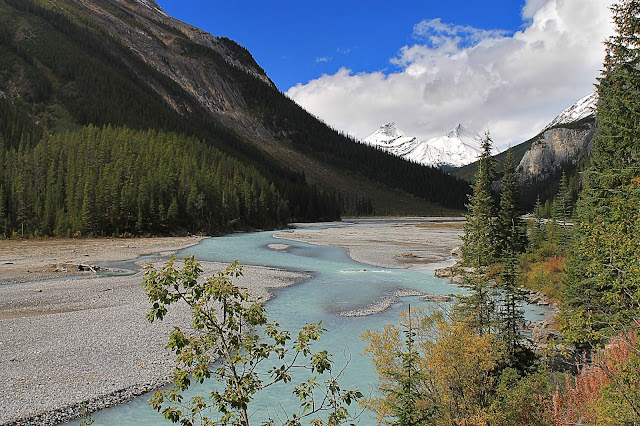
(Above) The Mistaya River also carries a load of rock flour. The valley shows the distinctive broad U-shape created by glaciation. The large amount of gravel is typical of a river that drains glaciers.
(Above) Steep mountainsides like this one above Waterfowl Lake are another indicator of glaciation. Glaciers freeze onto loose rocks on the sides of the valley and drag them away, leaving behind steep slopes and cliffs.
(Above) The Crossing Resort at the Saskatchewan River crossing and Highway 11 is the only sizable lodging between Lake Louise and the Icefields Interpretive Center. It has two restaurants and a small store in addition to the motel. Room rates are a downright bargain for the area. The location is stunning!
(Above) This is the view northward behind The Crossing Resort. You don't get that at just any motel!
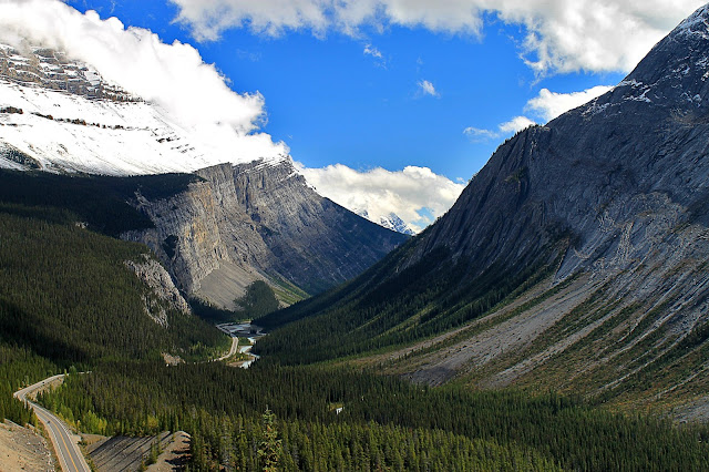
(Above) The distinctive U-shaped valley viewed toward the south from the big switchback at Parker Ridge.
(Above) This view is just to the right of the photo above, and it shows the steeply-dipping strata. When strata dip the same as the topographic slope, the mountainside looks quite different from others, with long tilted slabs with rounded or blunt arrow tops. This configuration also prevented the glacier from making vertical cliffs here.
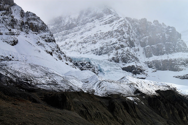
(Above) Once you get past the big switchback and closer to Jasper National Park, you start to see ice caps on the mountains. Mountain-top ice caps feed the valley glaciers below, sometimes cascading over cliffs like this one does.
(Above) Ice shelves slowly grow and slide, dropping avalanches of ice over the cliffs.
(Above) These coalesced glaciers are fed by an ice cap on the high mountaintop. The ridge of gravel at the lower right is the old lateral moraine from the Athabasca Glacier next-door.
Athabasca Glacier
Welcome to Jasper National Park!
(Above) Athabasca is the most accessible glacier around! This view is from near the visitor center. The glacier has retreated from the visitor center all the way to where we see it today (about 1.5 km) since about 1890, and it loses about 5 meters of ice each year.
(Above) Interactive Google map. When you pan to the southwest, you can see the extensive Columbia Ice Cap that feeds the glaciers.
(Above) Google Earth view of the Athabasca Glacier and neighboring ice cap and glaciers. Dome Glacier is the one to the right of Athabasca. The ice cap accumulated on the relatively flat top of the mountains, while the valley glaciers carve out and widen the canyons below. In mountains farther south in the U.S. where the glaciers are gone, we can still see the flat tops above U-shaped canyons (Wasatch, Lemhi, Sierra Nevada mountains to name a few).
(Above) View of the glacier from near the visitor center. You can drive closer to park and hike up to the ice. The hike is short, but does have one steep section visible here. It's rocky and irregular, suitable only for the most adventurous wheelchair operators.
(Above) This panorama shows the glacier and its lateral moraine (the pile of gray gravel to the right). Lateral moraines are the rocks and dirt that fell onto the ice back up in the canyon. The ice has carried all that material down to where the glacier melts, leaving behind a pile that shows us the former height and extent of the ice.
(Above) View from the glacier trail back toward the visitor center. The gray-green lake is filled with outwash from the glacier. All along the trail you walk through moraine material (called "till") and over bedrock scratched and polished by the glacier. The trail is marked with signs showing where the glacier's terminus was in years past.
(Above) Don't miss the side glaciers! They tumble out of the side canyons where they used to merge with the Athabasca glacier when it was thicker. Glaciers have that distinctive blue-green color that is mesmerizing in person.
(Above) The front of the glacier is marked by huge piles of gravel and a lot of melt water. The gravel covers glacier ice, shielding it from the sun for years.
(Above) Whether you can hike onto the ice depends on where the meltwater stream is in that particular year. In this photo, the stream was entirely on the northern end, so the trail went straight up onto the glacier. In another year I visited, the river blocked easy access to the ice.
(Above) I never really understood glacial processes until I visited Athabasca. The interaction between ice and rock and water is fascinating to see in action! There's more water pouring out of the glacier than I would have imagined, and there's more rock and gravel than I had thought a glacier could carry.
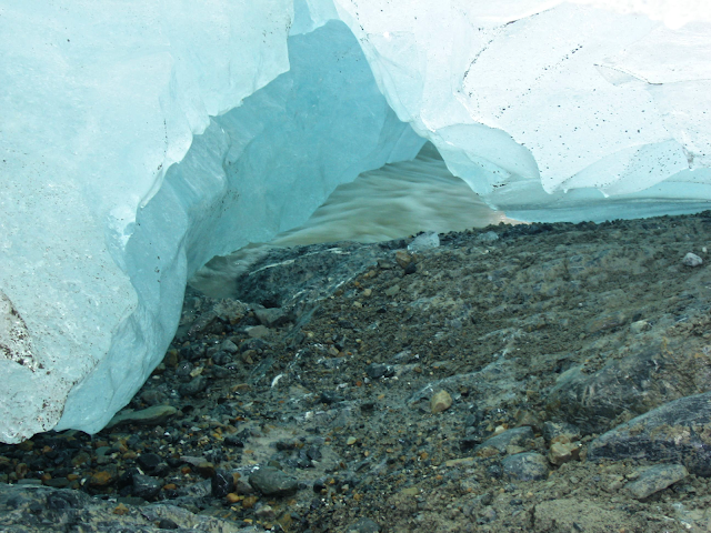
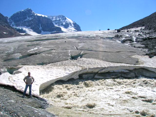
(Above) If you're lucky enough to get to the front edge of the glacier, look for where it has melted up off the gravel. Here you can see a meltwater stream flowing under the ghostly blue-green ice.
(Above) The meltwater stream is enormous in the warm months! Notice that the water is carrying a lot of silt and rock flour, and when you're close enough you can see and hear all the rocks tumbling along.
(Above) This was a surprise to me the first time I saw it -- a frozen lateral moraine. The glacier is to the left, having retreated past this point well over a decade ago. Gravel protects the ice from melting for many years. When you're close enough, you can hear rocks almost constantly tumbling down the moraine as the ice melts.
(Above) This is the outwash stream roaring across moraine boulders and polished bedrock.
(Above) The outwash plain consists of ground moraine gravel and a lake.
(Above) The bedrock was scratched by rocks being dragged under the weight of the glacier. The scratches are almost perpendicular to the bedrock layers.
(Above) Some of the bedrock here is fascinating, like this soft-sediment deformation. The wavy bedding was the result of deformation while this was still mud hundreds of millions of years ago in a distant ancestor of the Pacific Ocean.
<end of trip>
Related Posts: Banff Part 1, Banff South, Burgess Shale, Frank Slide, Glacier National Park
Park Website: Banff National Park
Canada Geologic Maps: Natural Resources Canada This site is awkward to use unless you know the exact name of the map you want. The "search using map area bounds" function doesn't always find geologic maps.
Canada Geologic Maps: Natural Resources Canada This site is awkward to use unless you know the exact name of the map you want. The "search using map area bounds" function doesn't always find geologic maps.


