20 Cool Geology Photos
Mostly on the U.S. West Coast
Some of the pictures I take while traveling don't fit neatly into distinct field trips, so I'll group them into posts like this. They still tell the fascinating story behind the scenery!
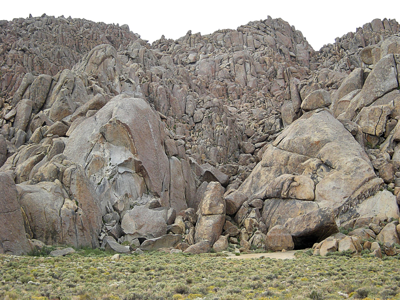
Alabama Hills, California
Have you seen the "Tremors" movies? The first one was filmed here, at the Alabama Hills in eastern California near the town of Lone Pine. The bedrock is the same Cretaceous granite found in the high Sierras. In these hills, however, it is strongly jointed in two directions, resulting in these boulders and towers that have such a unique appearance. Weathering by rain and ice widens the fractures and rounds the rocks.
View from near Whitney Portal over part of the Alabama hills in Owens Valley. So many famous movies have been filmed here, it's hard to list them all! From Iron Man to Gladiator, to the classic Gunga Din, here's a list that'll blow you away! Click here. A pair of big normal faults form the Owens Valley here, one at the base of the high Sierra escarpment and another just beyond the Alabama hills next to Lone Pine. That second fault ruptured in a big earthquake in 1872.
Cape Mendocino, California
Mendocino Rock on the northern California coast. This is a geologically significant spot because it is the "triple junction" between three plate boundaries - the San Andreas, the Cascadia Subduction Zone, and the Mendocino Fracture Zone. As a result, earthquakes here are frequent. The obscure Mattole Road from Ferndale to Petrolia is as lonely as roads get, and it takes you through complex and dynamic geology including many faults, folds, and landslides. I've seen several car commercials that were filmed here.
Mouth of Petrolia Creek on the northern California coast near Cape Mendocino. South-to-north drift of beach sand has deflected the river to the north, at times blocking it completely - a common occurrence on California's rivers. By the way, Petrolia was the site of California's first oil discovery in 1865.
You'll see these signs near Ferndale and Eureka. This isn't hypothetical - tsunamis have inundated these areas in recent years!
Crescent City, California
Back in my tucked-in-shirt days, I found this tsunami marker in Crescent City from the April 1964 Alaska earthquake. It did tens of millions of dollars of damage to the town. A smaller tsunami in 2011 damage boats and docks.
Sea stacks at Crescent City are made of the more resistant rocks in the tectonic melange, mostly graywacke (a sandstone with volcanic sand). Shale and other soft rocks have all eroded away. These rocks used to be in and near the subduction zone before the San Andreas fault developed several million years ago. Crescent City has been the site of damaging tsunamis caused by various Pacific earthquakes including 1964 Alaska and 2011 Japan.
The Crescent City lighthouse sits on a patch of solid sandstone in the tectonic melange.
High tides isolate the lighthouse, and storms pile up the driftwood.
Northern California Coast
The redwoods meet the sea south of Crescent City, California. This part of the coast will cast its spell on you, and you'll never want to leave!
Sea stacks on the northern California coast. The flat-topped areas above the cliffs, where Highway 1 is, are former beaches that were uplifted by tectonic movement. California isn't sinking into the sea, it's rising out of it!
This is a good look at the uplifted beach terraces on the northern California coast south of Crescent City. Wave erosion flattens the bedrock, then tectonic activity lifts it above sea level. In some places like Montana de Oro State Park, you can see as many as 9 uplifted beach terraces that record the uplift!
These much-photographed houses and remains are just north of Bodega Bay on the northern California coast. Wave erosion undercuts the cliffs, causing them to collapse and retreat, taking several houses with them. The remaining houses are protected from waves by the big sea stacks of basalt and metamorphic rocks. You can also see the remnants of futile attempts to protect the cliffs by concrete seawalls, but seawalls are counter-productive because they focus the waves' erosional power on the sand, causing removal of the beach and increased attack on the cliffs.
Central California Coast
The Miocene (about 4-14 million years) Monterey formation at Montana de Oro State Park on the central California Coast is the region's major oil producer. It is made of thin beds of silica silt and fossils called diatoms that in places are slightly metamorphosed to a porcelain-like texture.
The tilted Monterey beds create wonderful tide pools and channels to explore. One of my daughters said her first complex words here as a toddler - "sea anemone."
Columbia River Gorge
The Columbia River gorge just may be the origin of the word "gorgeous!" The enormous river drains a huge part of the Pacific NW and British Columbia. It was also the drainageway for the biggest geologic floods ever known - the Missoula ice-age floods that put water all the way to the tops of the cliffs in this picture. I'll have a field trip about that one soon.
The much-photographed Multnomah Falls in the Columbia River gorge along I-84 west of Portland. This stretch of the gorge has a couple dozen waterfalls. To see them, you have to take the old 2-lane "Historic Columbia River Highway" from Bridal Veil east. It's a slow drive that's completely worth the extra time.
St. Helens (left) and Mt. Adams (right) viewed from just north of Portland.
Cascades
Mt. Bachelor and the Three Sisters volcanoes near Bend, Oregon, viewed from the Newberry Caldera. All of the Cascades peaks are volcanoes. The steepest ones are the youngest ones, and any of them could wake up any day. I think the Cascades are best seen from the east side where the weather is a little drier and the vegetation is a little less.
Mt. Hood viewed from the north on the road from Hood River. It is thought that Hood had a minor eruption in 1805 because the Lewis and Clark party reported seeing dark, muddy water in a creek flowing from the mountain. It has occasional small earthquakes that indicate it is only sleeping.
Related trips: Look for the labels Cascades, Volcano, and each state's name.


