Death Valley - Badwater Area

Death Valley Part 1 -- Badwater Area

Explore the lowest place in the western hemisphere!

Why Visit Death Valley National Park?

Death Valley covers an astounding 3.4 million acres, compared to Yellowstone's paltry 2.2 million. It's so big, you would need several days just to see all the major stuff. So, besides being low and hot, what else is Death Valley? 

Geologically, it's a fascinating intersection of tectonic forces that created unusual low-angle normal faults that have pulled apart the crust, dropping it down between separating mountains. Telescope Peak at 11,043 feet overlooks Badwater's 282 feet below sea level -- that's an 11,325 foot tall mountain front! Where have you ever seen that?

The deep slices into the crust reveal colorful rocks altered by metamorphism and hydrothermal alteration, giving the park a palette to be envied and imitated by artists.

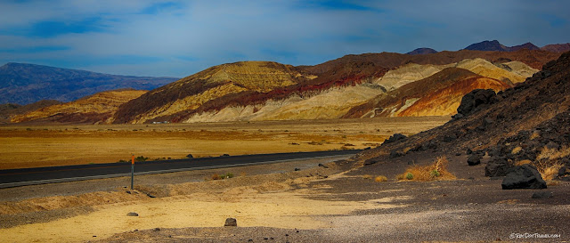
The extreme dry climate has preserved features not found elsewhere, like giant bedrock slopes polished and sheared by movement on a fault, wind-sculpted rocks, fault scarps, sand dunes, playas (dry lake beds), giant bajadas (an apron of gravel across the mountain front), and weather-varnished rocks.

You'll also learn the stories and see the works of miners of over a century ago, who endured unimaginable hardships to scratch a living out of this hostile environment.


Travel to Death Valley


Seasons: Late winter is best, when the flowers bloom and temperatures are still sub-furnace. Busiest times are Thanksgiving and Presidents Day. I seriously do not recommend going during the summer -- heat can cause too many things to go wrong, from stroke to overheated cars to flat tires.
Vehicles: Check over your vehicle before going! Cooling system must work perfectly with the air conditioning running. Tires must not be old or over-inflated (which could cause them to burst). 
Lodging: Good hotels are available in Death Valley! The Oasis at Death Valley (has also been called The Inn at Death Valley) is located on the east-central side where the road from Las Vegas / Pahrump enters the valley. My favorite is the Ranch, which is located out in the valley by the park headquarters. The National Park website has more information on lodging. 
Camping: Believe it or not, camping in Death Valley is awesome! The park has a couple of huge campgrounds near the Furnace Creek headquarters, and several others scattered around the area. See the complete list at the park's website
Backcountry Roads: Yes, you can go 4-wheeling in Death Valley! Be prepared for extreme conditions, and be well supplied if you go off road. The park's website has a comprehensive list of roads and precautions.
Hiking: Death Valley offers cross-country hiking through canyons, desert landscapes, mountains, and colorful bedrock that you won't find the equal of anywhere else. Most hiking is not on established trails -- it's cross-country, so you're in for a unique experience. Find lots more information here.


Interactive Google Map of the Death Valley region.
  

Geology of Death Valley

Death Valley is a "pull-apart basin" created by the interaction of strike-slip faults, which slide horizontally, and normal faults, which drop valleys down vertically. In this regard, it's similar to the Dead Sea in Israel. Being in California not far from the San Andreas tectonic plate boundary, it's under constant stress that keep earthquake potential high.


Death Valley is surrounded by uplifted mountains in all directions, which adds to the feeling of being in a deep, deep hole.  This is a view of Telescope Peak from just east of the park.


The Badwater playa (the dry lake bottom) is covered by evaporites including salt, calcite, gypsum, and borax. In particularly wet seasons, it can have quite a bit of water, but of course the climate is so dry and hot, the water doesn't last long. 
     Also in this view you can see Telescope Peak, which is just over 11,000 feet high. This is one of the highest mountain fronts in the U.S. outside of Alaska.
     The big apron of gravel is called a bajada, and it's absolutely enormous, over 5 miles from top to bottom. The gravel is deposited by flash floods from the mountains.
     Near the bottom of the bajada is a prominent fault scarp. It looks like a dark line not far above the spring-fed vegetation at the very bottom of the fan.


Here's a wider look over the valley (playa) and Telescope Peak high above.


Just south of Badwater is the Badwater Turtleback, one of three giant humps in the range-front fault system. The dry climate has allowed the scraped, stretched bedrock below the fault to be preserved for our viewing pleasure.


This lump of gravel has somehow survived on the fault surface without being washed away. It may even have ridden the bedrock upward during earthquakes.


The planar bedrock surfaces with a common tilt are the fault surface.  Lumps of valley gravel cling to it.  But let's be precise here: a fault is a boundary, it's not a "thing."  What we see here is the truncated boundary of the "footwall," or bedrock block below the fault.  


Here's a look at the fault surface from the parking lot located here: 36.281169, -116.770013     The light-colored material that ramps up onto the darker footwall bedrock is young gravel.


The orange to dark brown bedrock here is the fault surface. The wash has eroded right up to it here, but at the right side of the photo you can see a big block of valley gravel that remains and lies on top of the fault surface.  That gravel was deposited in the valley, and has been isolated by erosion.


Such fantastic shapes!  The light-colored material that lies directly on the fault surface is a more easily eroded 
This curious traveler is standing on the uplifted, polished bedrock and next to a patch of gravel stuck to the uplifting mountain block.


Here's the polished bedrock fault surface, with a geologically curious traveler for scale.


The bedrock below the fault is sheared for a few meters downward. The bedrock here is Precambrian gneiss and schist, about 1.7 billion years old.  The sheared fabric is called mylonite, and it formed when this bedrock was in the deep roots of the fault.


Here's a small patch of gravel sitting on the fault, with a curious choice of colors for a hat.


Lookout down the wash from the fault exposure, you can see the big salt pan.


This close-up shows the shear fabrics in the fault.  The fault is at the top of the red band, with gravel above it.  The difference in age between the two is about 1.7 billion years, nearly half of Earth's history!


The steep bedrock mountain front at Badwater is made of 1.7 billion year old metamorphosed volcanic and sedimentary rocks, which were later injected by a dark igneous rock (diorite and gabbro) about 11 million years ago. The steep scarp in shadow is a fault scarp along the Death Valley fault. It's about 2000 years old.


At Badwater, the playa salt comes right up to the mountain front.  That's an indication that faulting here is quite active and recent, because it has dropped the valley down enough to bring the water (when it's present) over to this side of the valley.  The mountain front is made of 1.7 billion year old metamorphic rocks.


That steep cliff in the gravel is the range front fault scarp.  It's probably only a few hundred years old.


South of Badwater, two strands of the fault cut this alluvial fan (a pile of flash flood gravel).  


A little wider view of the faulted alluvial fan shows its gradual concave profile.  Distance from top to bottom of the fan is half a mile.


This is the walkway out to the absolute lowest point, which is indiscernibly lower, so you may as well keep your hike short. 


Wind-eroded features like this are called "ventifacts."  Sand bouncing along the ground in high winds is a pretty efficient abrasive.  Just ask anyone from SW Arizona who has foggy headlight lenses.  These are along the road south of Badwater.


A wider view of the ventifacts and the ugly hat.


The colorful bedrock near Artist Drive is mostly volcanic (most of the hard cliff formers) with some lake and stream sediments in-between.  These are some of the youngest bedrock in Death Valley, "only" 10-20 million years old.


Looking northwestward, this is all Death Valley as far as the eye can see.


The Oasis at Death Valley (and its upscale section The Inn at Death Valley, formerly the Furnace Creek Inn) has been a popular destination for the rich & famous for many decades.  I was able to attend a week-long conference in its facilities, and it was wonderful!  
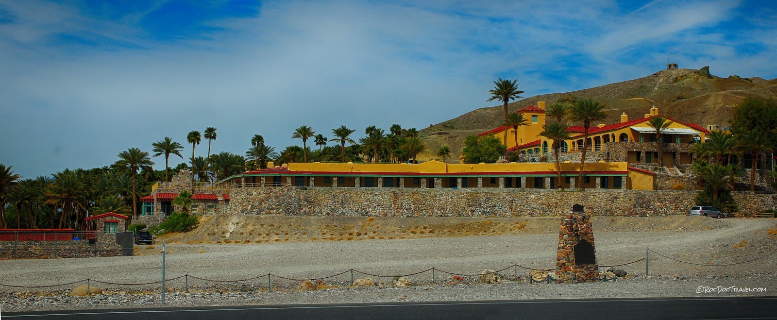
     Just down the road in the valley is Furnace Creek with its affordable ranch, park headquarters, and campgrounds.

More Death Valley field trips will appear in the near future!

Most Popular Posts

The San Andreas Fault: I-15 to I-5

Mouth of the Columbia River