Kilauea, Hawaii
Kilauea Volcano, Hawaii
Volcanoes National Park
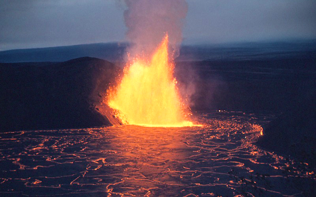
(Above) Kilauea Iki erupting in 1959. (USGS photo)
Got a bucket list? Make sure Kilauea is on it! We'll visit the best things to see at Kilauea, Hawaii, the most active volcano on Earth -- and part of the biggest volcano and biggest mountain on Earth!
For more on the 2018 eruption, please see my other posts.
Why Visit Kilauea
Hello! It's Hawaii! And it's an active volcano!The island of Hawaii (the "Big Island") is where the geologic action is. Kilauea has been erupting continuously since January 1983, making it the most active volcano and the best volcano laboratory on Earth. That means you have a good chance of seeing an eruption in one form or another. Plus, this island offers laid-back, friendly, and affordable accommodations in Hilo and Kona and and more great geologic sites at Mauna Kea, Hilo Bay, and South Point.
If you're fortunate enough to visit when a lava flow is active and accessible, I promise that seeing it up close will forever change the way you think about volcanoes. It's an incredibly sensory experience -- acrid odors, intense heat, rumbling clinking noises, and the realization that lava is absolutely unstoppable. You'll never forget it!
Visiting Volcanoes National Park, Hawaii
The 2018 eruption closed the Jagger visitor center. Check the National Park website for current conditions and closures.Time: 1+ day, but you'll want to linger longer. Get an early start so you're not at the coast at nightfall.
Difficulty: Easy. Prepare for the weather -- it can be very hot out on the lava flows, so take plenty of water and a shady hat. Easy to moderate hikes are available throughout the National Park.
Vehicle: For the National Park, any vehicle will do. If you want to go to South Point or Mauna Kea (described in separate posts), you should rent a Jeep.
Options: Helicopter tours are one of the best ways to see an eruption, especially when Pu'u O'o is putting out lava flows. If lava is entering the sea, take a dawn boat tour to see it!
Food & Restrooms: There are none past Thurston Lava Tube until you get to the coast, where there are restrooms and small daytime concessions. It's probably a good idea to pack a lunch and plenty of water.
Cautions: Always obey the numerous warning signs in the National Park and environs! Even old, cold lava can hurt you in many different ways, including collapse and very sharp edges. Unseen toxic gases are a wide-spread hazard as well.
Related Posts: Kilauea by Helicopter, Kilauea by Boat, Hilo Bay, South Point, 2018 eruption, Mauna Kea.
What to Look For: Active eruption, cinder cones, lava tubes, a'a, pahoehoe, tree molds (where lava wrapped around a tree trunk), Pele's hair, covered roads.
Visit my "Volcano Primer" page to learn the rock types and features you'll see at a volcano.
(Above) View of the Halemaumau caldera atop Kilauea from the Jagger museum in 2008. The eruption in the sign's photo took place in 1924.
Tour of Kilauea Volcano
From Hilo or Kona, follow the signs to Hawaii Volcanoes National Park Jagger Museum. It's located just west of the town of Volcano and next door to the Volcanoes Observatory on the rim of Kilauea's nested calderas. 19.420074, -155.288847 The elevation up here is about 4000 feet, so it is usually a bit cooler than down by the ocean. The main caldera is called Halemaumau. The Volcano Observatory has a terrific website with pictures, videos, and current information. volcanoes.usgs.gov/kilaueastatus.phpWhen it's open (check their website), the museum has a terrific view of the calderas and excellent information and displays inside. A caldera is a collapse feature caused by eruption of a volcano, and in this case the main caldera is broad compared to its depth. Other calderas like the one at Crater Lake, Oregon (see other post) can be thousands of feet deep. Until May 2018, the eruption was in a crater within the smaller caldera within the big caldera -- got it?
Jagger Museum is located on the rim of Kilauea's nested calderas.
Look for the Pele's hair in the museum. When droplets of lava fly through the air at high speed, they string out into fine hairs. Pele's hairs sometimes blanket the ground from a small eruption, only to decay and disappear in the sun and rain. The museum also has good photos of previous eruptions.
(Above) Pele's hair from a splashing eruption at Halemaumau in 2015. It's golden because of subtle corrosion of the basalt (USGS).
(Above) View of the Halemaumau lava lake in January, 2015. It's constantly changing, so will probably be different when you visit. In fact, it drained suddenly and violently in 2018 and is now more than 1100 feet deeper and much, much larger. (USGS photo)
Geology of Kilauea Volcano
It's all because of the type of lava -- basalt. Basalt is rich in iron and magnesium -- fairly heavy metals that give it its dark overall color -- and poor in silica. Silica is what glass is made of, along with a lot of other light-colored minerals and rocks, and silica is thick and rigid even when molten. Since basalt is poor in silica, it is runny when it erupts.
Volcanoes are exactly like carbonated drinks in that they have gasses held in their liquid by pressure, just like Coke has CO2 in its liquid that is held there by pressure inside the can or bottle. When you release the pressure by popping the top, CO2 comes out of the liquid, expands A LOT, and forces the Coke out of its container. The same thing happens with volcanoes -- liquid magma (the name for molten rock underground) contains gases that are held in the liquid by pressure. When the magma rises to near the surface, the pressure on it decreases and the gasses start to expand and come out of the liquid. So what happens to make a fountain, curtain, or explosive eruption is the depressurized gasses expand and force the lava out of its container, the volcano's plumbing system of fractures, tubes, and passageways. Because basalt is so runny, expanded gasses cause it to squirt up and out of the volcano.
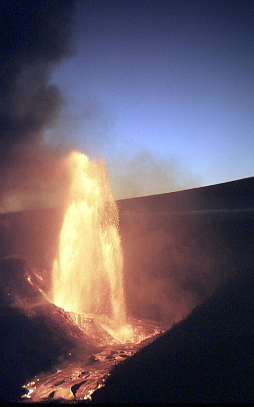
But what if the magma is high in silica? Watch out! Silica is so thick, the lava can't simply let the bubbles form and flow out, but instead the expanding bubbles break the lava in a violent explosion - the magma explodes from the inside out! That's what happened at Mount St. Helens (see other trip) -- a landslide "took the cork out," causing an instant, sudden release of pressure on the magma and the resulting 9-hour explosive eruption. At Kilauea, expanding gasses caused the spectacular eruption in 1924 (pictured at the museum) and the 1900-foot fountains at Kilauea Iki (next stop) in 1959.
(Above) Lava fountain during the 1959 eruption of Kilauea Iki (USGS photo). It's like a giant Coke bottle erupting!
Lava types. You'll see two types of lava while in Hawaii. Smooth or ropey texture is called pahoehoe (pa-hoi-hoi), the Hawaiian word for "ropey." Blocky, jagged lava is called A'a (pronounce both A's), which is probably what you would say if you walked across it barefoot. Subtle differences in temperature, chemistry, and flow rate cause one lava flow to form pahoehoe while one next door might form a'a. This video will help you understand pahoehoe textures: Pahoehoe And this one shows an A'a flow: Aa flow
(Above) A Pohoehoe flow over A'a. The silver glass that coats new lava weathers away quickly in the Hawaiian rain. (USGS photo)
Next Stop: Kilauea Iki (little Kilauea) 19.416501, -155.242933
From the museum, take Crater Rim drive clockwise around the caldera until you get to the parking area for Kilauea Iki.
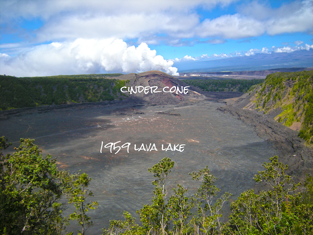
Before going there, you should watch this video of Kilauea Iki's eruption in 1959: Kilauea Iki A lava fountain reached over 1900 feet (580 meters) high! The caldera floor you see today was a liquid lava lake. The fountaining lava formed the cinder cone you can see across the caldera (see below for a good hike out there).
(Above) View from the Kilauea Iki overlook, the same view as in the fountain photo above. The cinder cone was formed by that same lava fountain in 1959.
From the view area, you can see the Kilauea Iki crater that was a lava lake in 1959 and the cinder cone on the far side formed by the lava fountain. The fountain was low on the right side of the cinder cone. If you're a National Geographic subscriber, you can read their article in the March 1960 issue here: NatGeoMarch1960 Notice the dark, rough-looking rim around the crater floor. This rim was formed during repeated filling and draining of the lava lake in 1959. Also look for the collapse features on the cinder cone. It was built of lava pieces (tephra) that built up so fast, the cone was unstable as a preschooler's sand castle, and began to collapse in pieces during the eruption. The Crater Rim hike to the right gives you great additional views, and for the really adventurous you can hike across the crater floor from the Kilauea Iki trailhead at the next stop.
Next Stop: Thurston Lava Tube 19.413576, -155.238793
Down Crater Rim Drive after two or three curves is the parking area for the Thurston lava tube. This lot is also the trailhead for the Kilauea Iki trail across the crater floor. The lava tube is on the other side of the road.
This is an easy adventure. You can enter the bowels of the volcano with no risk of fiery, gassy death.
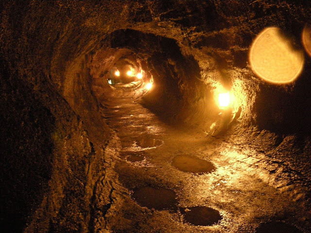
(Above) Thurston lava tube, part of Kilauea's hidden plumbing system.
How do lava tubes form? Lava cools and hardens when it comes in contact with the cold air (in Hawaii, "cold" is a relative term!). That means that most lava flows soon cover themselves with a rigid crust on top, and voila! -- lava tube! Tubes can also form wherever the lava (technically magma, because it's underground) finds a pathway through the rocks, often along fractures. When the lava supply is cut off or diverted into another tube, lava in the tube drains out, leaving the tunnel you're walking through.
Lava tubes are under all active areas of Kilauea, all the way down to the ocean. Some are shallow enough and have thin enough roofs to pose an unforgettable hazard, so always obey the warning signs!
The best lava tubes I've ever seen, and definitely the biggest, are in Craters of the Moon National Monument in Idaho (see other trip). But Thurston gives you a great, if moist, experience.
Next Stop: Craters along the Chain of Craters Road.
Stop by and see Luamanu, Puhimau, Devil's Throat, Hiiaka, and Pauahi craters, all just off the road. Keep in mind that none of these is more than about 300 years old! By comparison, Crater Lake in Oregon is about 7700 years old.
Next Stop: Volcano Tree Molds 19.364937, -155.215127
You could go to Volcano Trees State Park near Pahoa, 19.482917, -154.904367 but these tree molds are a LOT better!
After Pauahi crater, turn left onto the road to Mauna Ulu and go to the parking at the end. Walk down toward the end of the road to the signs that show and describe the Napau trail, and turn left onto the Napau trail or any of the paths that heads north (toward Halemaumau's steam plume). This is not the trail at the end of the road, which some maps call the Napau trail. Go about 150 yards to the kipuka (remnant of forest), and go off the trail to the left about another 100 yards to find a group of lava trees. 19.367767, -155.214288 Wander this sparsely-treed area to see more tree molds and a lot of fascinating lava features. (We'll go the other direction, south, to the Mauna Ulu eruption fissure after this.)
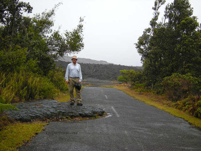
(Above) Turn left here or at the big, colorful sign to go on the Napau trail. The traffic hazard formed in 1973, and the big A'a flow in the background finished off the road in 1974.
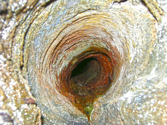
How Tree Molds Form This is counter-intuitive, so get your brain ready! You'd think that lava would instantly burn the trees, right? Not so, at least here! The native trees here have a high water content, and so make excellent heat sinks, and the lava was just hot enough to flow. When the lava contacted the tree trunk, some of the lava's heat was transferred to the tree, cooling the contact surface of the lava and causing it to harden. Look closely at the pictures below, and you can see that the lava wrapped around the tree trunk like blankets as it hardened. The imprint of the tree's bark was left on the inner surface of the lava! On some of the tree molds, the higher trunk and branches of the trees remain where they fell when the trunk burned away.
Here's something else that's counter-intuitive: Why are the tree molds so tall? The answer has to do with lava tubes and how lava flow fields work. Lava flows tend to inflate from below as they grow. Lava feeds to the front through tubes and mini-tubes, lifting up the hardening material above it. The tops of the tree molds mark the maximum height of the lava flow. This lava flow deflated -- lava under the lifted, hardening surface flowed away downhill, causing the hardening surface to lower. But because the lava at the trees was already hardened, it remained tall as the lava flow deflated around it. Cool, huh! Or is that "hot?"
(Above and below) This tree mold is about 12 feet tall. The tree's upper trunk and branches lay where they fell when the trunk burned away.
Next: Go back to the road by going back to the kipuka and the trail, or just walking downhill, and take the short walk south to the Mauna Ulu eruption fissure, formed in 1969. Eruptions at Kilauea (and all basalt volcanoes) almost always begin along a fissure because lava rises through the crust along fissures. When the lava's bouyancy forces the lava all the way to the surface, the fissure opens at the surface and lava pours out. On this short hike, you'll see a splatter wall, which is blobs of lava all coalesced together from the squirting fissure eruption. Pretty cool!
Options: The hearty can hike to Mauna Ulu, a nice crater that erupted in 1974, or all the way to Napau crater (Mauna Ulu is the most interesting, in my humble opinion).
Back to the car!
Next Stop: Muliwai O Pele. 19.327534, -155.192299
Park in the pull-out at Muliwai O Pele ("channel of pele"). The platform has a spectacular overlook you won't want to miss.
This trench was a channel through which lava from the 1974 Mauna Ulu eruption passed down to the pali (the steep slopes below). Upper parts of the channel were lava tubes, but here it was a kind of lava canal. High flows built levees on the sides, effectively deepening the channel. Pieces of hardened lava were tumbled along in the flow.
Last Stop: The Pali and Coast -- restrooms and daytime concessions
Drive down the Chain of Craters Road all the way to the coast. There are restrooms and daytime concessions at the end.
The road slices diagonally down the Pali, which is essentially the head scarp of a gigantic landslide. Because volcanoes like Kilauea add more lava to their surfaces than the resulting island has time to stabilize, giant landslides occur. This landslide moves about 2 inches per year, so there's no immediate danger, but over thousands of years each of the Hawaiian islands has undergone catastrophic collapse.
(Above) Google Earth view of the road where it slices down the pali. The road crosses a series of young lava flows where they cascaded down the slope at high speed.
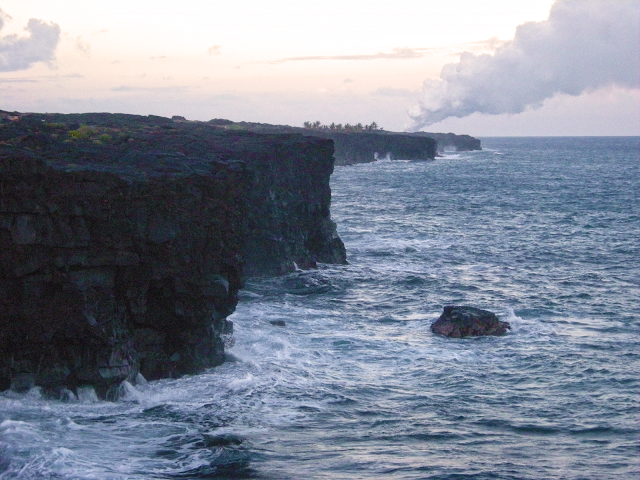
Take a look at the beautiful sea cliffs. The lava flows used to extend farther out into the ocean, but erosion and collapse have moved the cliffs back to where you see them.
(Above) Sea cliffs near the bottom of the Chain of Craters Road. The steam plume in the distance is from lava entering the sea.
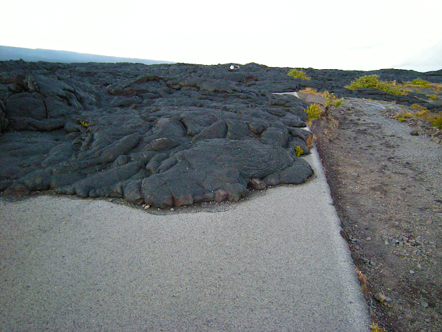
After not too far, you'll get to a turn-around for the Holei Sea Arch where the road is blocked. There are restrooms and daytime concessions here. It's worth it to walk a few hundred yards farther to where the road is blocked by lava flows. 19.299235, -155.089908 This is an excellent place to see pahoehoe forms, and a relatively safe and easy place to walk on the flows.
(Above) The road has been covered by lava flows many times and for many miles. Recently a narrow gravel road was built along the old roadway for emergency use only.
(Above) This patch of pahoehoe is about as big as your living room floor, and it looks like dragon skin!
From here, you drive back up the Chain of Craters Road to Volcano. If there ever was a pleasant road to repeat, this is it!
~ end of trip ~
See also: Kilauea by Air and Sea
and 2018 Eruption posts.
