Mouth of the Columbia River
Mouth of the Columbia River
"Graveyard of the Pacific"
Explore the biggest river on the Pacific Coast, the goal of explorers for two centuries, and the graveyard for over 2000 ships!
A Geological, Geographical, and Historical Monument
The mouth of the Columbia was the objective of explorers including Lewis and Clark, John Jacob Astor's trade empire aspirations, and others who thought the big river would provide a travel route across the continent.
What they didn't know was that the Columbia comes south out of British Columbia instead of proceeding nicely westward from the U.S. Rockies. The only tributary that does come out of the Rockies is the impassible Snake, which has hundreds of miles of waterfalls, rapids, and formidable canyons. Lewis and Clark had high hopes to take the Salmon River from the continental divide westward to the Columbia, but like the Snake, the Salmon is filled with rapids in impassible canyons that are challenging even today.
Lewis and Clark reached the mouth of the Columbia on November 20th, 1805 via their northern route. An overland expedition sent by John Jacob Astor, later known as the "Astorians," reached it in January, 1812 after tremendous hardship traveling along the Snake River. The Astorians left a lasting and invaluable contribution to westward migration - discovery of the "South Pass" (as opposed to Lewis and Clark's more difficult "northern pass" over the Rockies) that would become the Oregon Trail.
The mouth of the Columbia is unusual for a big river because it has no delta. Instead, sediment is transported down subsea canyons to deep water, leaving the river mouth subject to waves, tidal flow, and currents. It's the most treacherous place for ships on the Pacific coast.
Travel to Astoria, Oregon
Interactive Google Map. Follow the signs westward from Astoria to Fort Stevens State Park at the mouth of the Columbia.
Vehicles: This trip is suitable for any vehicle.
Lodging: Plenty of good lodging is available in Astoria in all price ranges. Good camping is also available year-round by reservation at Fort Stevens State Park.
Seasons: Fort Stevens is open all year, but winter months are quite stormy.
Logistics: This is one of the simpler trips in rocdoctravel.com. You're never very far from restaurants, stores, and fuel stations.
Astoria


To get to Fort Stevens State Park, take highway 101 west to Warrenton and follow the signs. This is the view from Warrenton back to Astoria.
Fort Stevens State Park

The sandy peninsula leading to the river mouth is Fort Stevens State Park. Take the NW Ridge Road through the park to Peter Iredale Road, and turn west.


Looking northward from the Peter Iredale beach, you can see the great south jetty that protects the Columbia river mouth. Sandy spits like Fort Stevens shift over time as they are reworked by storm waves. This beach did not exist when Lewis and Clark got here - the spit has migrated a mile oceanward!

Looking from stern to bow of the Peter Iredale. Over a century of salt and water have dissolved most of the ship.

Only the thickest steel girders remain.

Not much is left of the bow. The gaps were not windows, they were the thinnest parts of the steel hull, now eaten away by salt.

Compare this 2016 picture to an early photograph of the wreck (below).
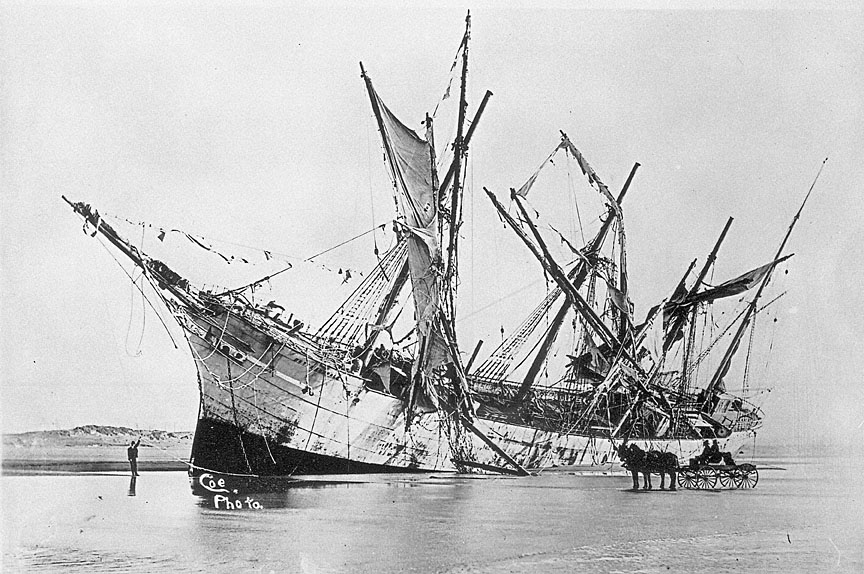
The Peter Iredale shortly after the wreck. (from oregonhistoryproject.org)
From Peter Iredale beach, take the Burma road north to the Jetty Road. These pilings are remnants of an old rail trestle used to build the south jetty.
Columbia River South Jetty
Jetties were built in the Columbia river mouth to protect and maintain shipping channels. Storm waves and incessant river and shoreline currents move tremendous amounts of sand every day, and jetties are necessary to control sand movement and stabilize channels. They also reduce the size of waves landward of the jetties. Without them, shipping channels would change unpredictably and would be tremendously expensive to maintain by dredging.
You can read a detailed history of the jetty here.


Navigation chart from the U.S. Army Corps of Engineers. The blue areas are exposed at low tide. The jetties were constructed to maintain the deep navigation channel by 1) keeping the river mouth channelized to maintain enough flow to keep sand transported out to sea, 2) to prevent sand from migrating into the river mouth, and 3) to control waves in the channel.

Part of the railroad trestle used to construct the jetty.

The observation tower offers great views.

Construction of the jetty took place between 1885 and 1895. The jetty was made by building a railroad trestle and dumping boulders. The frequent large waves here made construction by boat impossible.

Looking southward from the observation tower, you can see the wide beach that is stabilized by the jetty. Also notice the driftwood that has been tossed to the top (and over) the jetty by storm waves.

As the sign explains, the spit (a sand peninsula) has migrated over a mile oceanward since Lewis and Clark got here in 1805.

The south jetty is 6.6 miles (10.6 km) long.

The blue-green rocks in the jetty are metamorphosed oceanic crust. Originally basalt, this rock was shoved several kilometers down the subduction zone under North America, where its minerals were transformed by high pressure. Later uplift brought these rocks back to the surface, where they were quarried to build the jetty.

The gray rocks are basalt or a volcano-derived sandstone called graywacke, which is characteristic of convergent plate margins.

You can still see the railroad trestle in the jetty.

Some boulders have drill marks from quarrying. The early core of the jetty was made of basalt from the Fisher quarry near Vancouver, Washington, but many of the cover rocks were obviously quarried elsewhere because they are from tectonic melange that only occurs in the coast ranges. In searching for information on this quarry, all I can find is the dates of jetty rehabilitation during which the melange rocks must have been placed (likely in 1962). Rehabilitation of the north and south jetties is occurring in 2015-2018, but using granite from quarries near Tenino, Washington.

This graywacke has wavy bedding and medium to coarse grains. It was deposited during the late Jurassic or early Cretaceous era about 200-140 million years ago.

Driftwood and sand have accumulated on the landward side of the jetty. Watch this video of the jetty in a storm - it's dramatic, and explains how the wood and sand got over the jetty.

Small dunes deposited by storm waves have grown up onto the landward side of the jetty.

This panorama shows the mouth of the Columbia River. There is no easy way to hike along the jetty - it's a boulder-crawl all the way.

The far end of the jetty has been destroyed by storm waves. Reconstruction is slowly taking place by the U.S. Army Corps of Engineers. (NOAA photo)

These southward-sweeping waves move sand from the jetty toward the beach. In general, sand here moves northward in the summer and southward in the winter, depending on the wind and wave directions.

These southward-sweeping waves move sand from the jetty toward the beach. In general, sand here moves northward in the summer and southward in the winter, depending on the wind and wave directions.
Ilwaco and Cape Disappointment, Washington
Cross the Astoria - Megler bridge north into Washington.
The Columbia River mouth has fairly narrow channels at low tide, as seen here with a huge cargo ship. With the help of some coastal engineering by the U.S. Army Corps of Engineers - including the three jetties - and periodic dredging in key spots, the river's flow maintains a navigable southern channel out to the sea, and a smaller northern channel.

Here's a view across Baker Bay's mud flats to Cape Disappointment at low tide. This is from the National Park Service: "In 1788, while in search of the Columbia River, English Captain John Meares missed the passage over the river bar and named the nearby headland Cape Disappointment for his failure in finding the river. In 1792, American Captain Robert Gray successfully crossed the river bar and named the river "Columbia" after his ship, the Columbia Rediviva. Only a few years later, in 1805, the Lewis and Clark Expedition arrived at Cape Disappointment. It was at the base of Cape Disappointment that the Corps of Discovery achieved their principal mission of traveling across the continent to the Pacific Ocean.... The Cape Disappointment Lighthouse was constructed in 1856 to warn seamen of the treacherous river bar known by then as "the graveyard of the Pacific." This is the oldest functioning lighthouse on the West Coast."

The harbor at Ilwaco on Cape Disappointment. The nearby Coastguard Station is one of the most important and active on the Pacific coast. They rescue and train in the "graveyard of the Pacific" in the mouth of the Columbia, where 20 foot surf, 30 foot seas, and 50 knot winds challenge the best of mariners and the greatest ships. Read more of their mission and training at their website.

These men either have work to do on the mudflats, or they have a strange idea of "recreation!" The Ilwaco harbor is connected to the river by a dredged channel.

At low tide, this driftwood seems far out of place. At high tide and during storms, it's a whole different story!
Related trip topics & trips: Washington, Cascades, Oregon, Volcanoes


