Kilauea,Hawaii Eruption, 2018
Kilauea, Hawaii Eruption 2018
Part 1: A look at the lava flows and damageFor more on the effects and history of Kilauea eruptions, see Part 2.
See also my other Kilauea posts from earlier years: Kilauea by Air & Sea, and Kilauea (Hawaii Volcanoes National Park) for more volcano history and sights including Halemaumau caldera, other craters & cones, lava tubes, and lava trees.
Travel Tips for Hawaii
There are so many good websites about traveling to Hawaii, I don't really need to say much here!You can fly to either Hilo or Kailua-Kona -- check prices from your airport. Kona is a 2-hour drive from Hilo. Volcanoes National Park is a 30-minute drive (uphill!) from Hilo.
Check for flight + hotel packages, which can save you a lot of money.
Rent a Jeep: I recommend renting a Jeep so you can go to the top of Mauna Kea (see Mauna Kea post; 4x4 required) and out to some of the best beaches.
Weather: Prepare to sweat June through September! Hawaii is humid and hot, especially in the sun. The Big Island is hotter than advertised. Also prepare for frequent rain in the Hilo & Kilauea area, where the coast gets about 130 inches per year and higher slopes on Mauna Kea get over 300 inches! On the dryer west side, Kona only gets about 32 inches of rain per year. You'll discover that rain in Hawaii is quite comfortable -- many people (including me) choose to just get wet!
Eruption Facts
Eruption dates: May 4 - August 9, 2018
Area covered by lava: 13.7 square miles
New island land created: 875 acres (1.4 square miles, 3.54 km2)
Homes destroyed: 704
Total structures destroyed: over 1000
Fissures: 24 eruption fissures opened during May
Lava thickness: Around 150 feet along the main channel from Fissure 8. Over 50 feet over much of Leilani Estates.
Lessons Learned: Flow of Information and the USGS
Kilauea's eruption in 2018 is a perfect example of the importance of accurate information in this age of the unfiltered internet.As an example: When the eruption started in May, the Steamboat geyser in Yellowstone coincidentally had several rare eruptions at about the same time. The internet went nuts! Wild speculations were widely distributed, claiming that the two were somehow related, that Yellowstone might also erupt, and Kilauea could have an explosive eruption like Mount St. Helens had in 1980. Yikes!
The scientists and staff of the U.S. Geological Survey -- the authorities on Kilauea -- deftly took control of the flow of information. Using social media almost hourly and traditional media outlets in addition to their own wonderful websites (especially the Hawaii Volcanoes Observatory), they immediately responded to rumors and speculation. In easily understood language, they explained exactly what was happening in Hawaii, what the possibilities and uncertainties were, and they corrected the speculations. Local authorities in Hawaii, including the Hawaii County Civil Defense and the major news outlets, strictly quoted the USGS on all matters volcanic. This masterfully orchestrated communication was a marvel to behold! I don't think better scientists - to - public communication has happened since NASA's missions to the moon and the Mars Rover.
The result was that people's fears were calmed, wild speculators were put in their places, and trust was built between the public and the scientists (and those managing the emergency).
One problem that I observed in Hawaii, and many have commented on, is the lack of public access to the eruption. There was not one place on the ground where you could see any of the new lava. The best anyone could see was "lava glow" in the clouds and steam, best seen from the Sacred Heart Church in Pahoa. To see anything, you had to take an expensive helicopter or boat tour (as I did for this trip). This caused justifiable consternation among residents and visitors. Everyone understands the safety concerns -- the eruption was quite unpredictable, and will be into the future -- but please, authorities, find a spot where we can see something of what's going on!
The Early Eruption
The eruption began in early May with fissures opening in the Leilani Estates neighborhood. They were formed by magma rushing northeastward from the Puu Oo cone that had been erupting for decades, following fractures underground and forcing its way up to the ground surface.Sequence of events:
Late April, 2018 -- The lava lake in Halemaumau crater at Kilauea summit fills and overflows.
May 1 -- Lava suddenly drains out of Puu Oo crater, dropping its floor more than 1000 feet. Evidently, a passage out to the East Rift Zone had suddenly unplugged, starting massive movement of magma to the northeast.
Hundreds of earthquakes begin, following the magma's movement. Cracks begin to appear in the ground in Leilani Estates.
May 2 -- More cracks appear, and earthquakes increase.
May 3 -- Magnitude 5.0 quake rocks the east rift zone,and fissures appear in the lower east rift zone in Leilani Estates.
May 4 -- The first fissure erupts in Leilani Estates. A magnitude 6.9 earthquake rocks Kilauea and the entire island (2nd largest magnitude in Hawaii history). Lava drains out of Halemaumau, and summit collapse begins.
Sequence of events at the eruption sites: Frequent small quakes, cracks open, gasses (mostly sulfur dioxide and water vapor) erupt, then lava spurts and fountains out. In some cases, this entire sequence only took a couple of hours!
The most informative videos from the 2018 eruption were taken by residents of Leilani Estates and locals before they were evacuated. From these videos, you really get a feel for the noxious smells, explosive sounds, pulsating ground, and intense heat of the eruptions.
Informative close-up videos:
Fissure 1 begins
Fissure 2, May 4th
Fissures May 7th
May 8 Fissures Erupt
Fissure 3 steams and erupts
Early eruption on Leilani Street
Fissure 5 Awakens -- fascinating in-person video!
Fissure 8 begins
May 8th, Fissure 8
Makamae Street Lava
The Eruption By Helicopter
The U.S. Geological Survey provided outstanding pictures and videos throughout the May - August eruption, like these linked below. In the June 29 video, you see the "Fissure 8" eruption going full blast, about 110 cubic yards of lava per second! The temperature was hotter than most eruptions, about 1170 C (2140 F).
Click on the picture or the link below each picture to go to the video.
Lava enters Kapoho Bay June 4th
My helicopter flight was August 15, 2018 just as surface flow activity was ending.
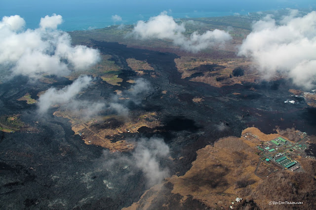
View to SE of the Puna Geothermal Venture (PGV), with Leilani Estates behind it. The major lava river channel is to the right of the PGV, with Fissure 8 behind a cloud. The channel had stopped flowing on August 9, so at the time of this picture it was crusted over, with lava still flowing underneath.
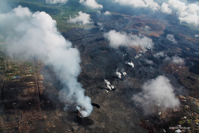
View to SE along the fissures, many of which are still steaming.
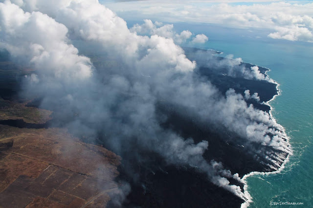
View to SE of the early lava ocean entry downhill from Leilani Estates. These flows cut off vital access to many homes and farms.
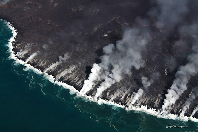
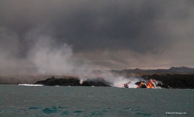
The most active ocean entry on August 15th. For scale, the cliffs are 20 to 30 feet high. This lava is draining from under the crusted-over lava channel.
The dark hump on the skyline is Mauna Loa, summit elevation 13,678 feet (4168 m). At a volume of a staggering 18,000 cubic miles and thickness of 55,000 feet, it is the world's biggest volcano! Kilauea is its younger successor, although Mauna Loa is still active. Leilani Estates is at the upper center.
Here's a little better view of Mauna Loa on the skyline, with the early ocean entry flows at the bottom.
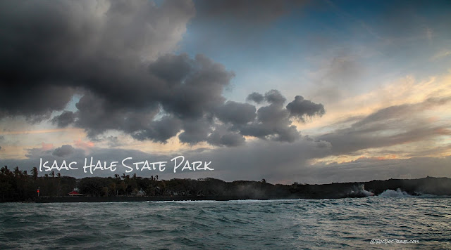
Isaac Hale State Park's boat ramp was the last non-helicopter access point for this corner of the island. Two days after I took this photo, black sand drifted across the small harbor mouth, cutting access.
This was the boat dock where we launched in my previous post (Kilauea by Air & Sea).
View to NE at the ocean entry south of Kapoho Bay. Isaac Hale State Park is just off the bottom of the photo.
The Puna geothermal power plant shut down as the lava flows approached. They were smartly located on high ground near those two older cinder cones, and so avoided major damage. But now that the lava flows have raised the ground around them, they are in future harm's way.
View northward of the major lava channels (dark) north of the power plant. Flow was left to right (northeastward) in this view.
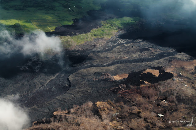
So many homes were just on the edge of the lava! They can be lived in again if the flows don't return, but will have to come to terms with living in an extremely dangerous place. Eventual destruction of these houses is certain -- but no one can know when.
"Fissure 8" at the bottom of the picture was the focus of eruption from late June to the cessation in early August. On August 15, two small lava pools in the cone were weakly feeding flow under the existing channel. Fissures to the northeast continued to spew sulfur dioxide and water vapor for many weeks. The PGV is in the top right of the photo (its buildings are green).
This is a Google Earth view of the same area in the previous photo, showing the streets and houses in Leilani Estates before the eruption. The PGV is in the upper right (green buildings). As of this writing, the naming committee had not yet settled on an official name for the cone. I would suggest "Loana cone," since it erupted on Loana street in Leilani Estates. View is to the north.
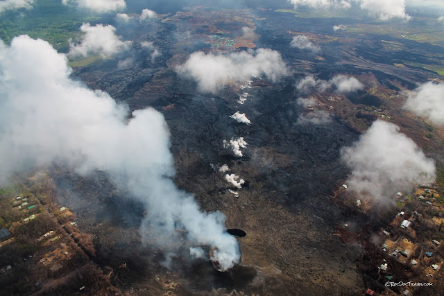
View to NE from above Fissure 8 along the fissure zone. Because the earliest eruptions northeast of Fissure 8 raised ground level by as much as 100 feet, the big eruption from Fissure 8 was diverted to the north, and flowed northeastward where it destroyed Kapoho Bay and Vacationland. Had the terrain around the fissure been slightly different, the flows would have gone directly down slope southward (to the right in this photo) to the ocean. Future eruptions here could still do so.
View to the east from Fissure 8 to the early ocean entries. Note the surviving houses in Leilani Estates to the right.
A steep view of Fissure 8 and the westernmost lava. Notice how surviving houses' yards are covered by black tephra -- rocks, sand, and dust from the erupting cone.
View SE of Fissure 8 and southern Leilani Estates.
The western end of the fissure eruptions. Notice how much dead vegetation there is. The usual lush tropical vegetation couldn't survive the sulfur emissions, but the effect was only within a mile or two.
The Eruption By Boat
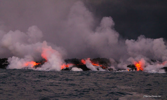
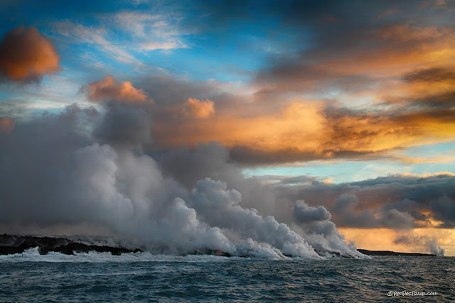
An excellent way to see lava ocean entry is by boat before sunrise or at sunset, when the glowing lava is most easily seen. For scale, the lava cliffs are about 20 to 30 feet high. At this time, tour boats were kept 300 yards from the lava by the Coast Guard after one boat was hit by exploding lava, injuring several people.A pre-dawn video of steamy lava ocean entry.
Lava here is traveling 8 miles through tubes under the crusted-over channel from Fissure 8.
The fissures and ocean entry spewed so much sulfur dioxide and water vapor, they created their own weather. Much of the island was clouded over throughout June and July, so slowing of the eruption was a big relief to residents not directly affected by the lava.
Seeing the lava ocean entry in person is a multi-sensory experience. The water is hot, the air is steamy and acidic-smelling, the lava pops and roars, and you're fully enveloped in the experience.
This is what it's like on the boat. We sailed from Hilo on Hawaiian Lava Boat Tours, a conscientious and excellent company.
Over the past several years each time there's been a lava ocean entry, I've wanted (badly!) to leave everything to go see it by boat (see my first post on Kilauea by Air & Sea). I was fortunate enough to have a generous sponsor to make it happen this time!
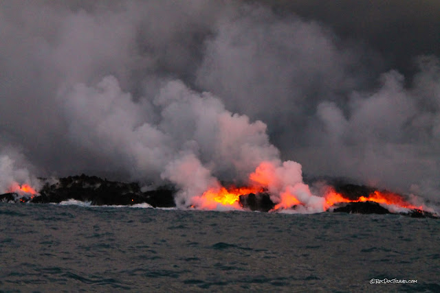
One of our boat crew members told us his house is under 150 feet of lava not far from here.
The southern end of the ocean entry. 2000 degree lava hitting water creates tremendous noxious clouds!
This was the southernmost entry, right next to Isaac Hale State Park and its vital boat ramp.
A look at Isaac Hale State Park, just days before black sand drifted across the harbor mouth. This was the only non-helicopter access point to this part of the island, important to hundreds of residents.
This was the "new island" that got so much hype in the press. It's just an outlier where a little lava erupted upwards to form this rock. It will soon be gone, eroded and broken to bits.

Here are some good reasons to take a sunrise boat tour!
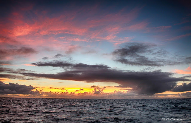
And no Hawaiian trip post would be complete without a picture of a rainbow!
Go to Part 2 -- Effects and History
Summit collapse, degassing fissures, other flows on Hawaii.
M.S. -- More Science
An excellent, readable history of Kilauea's eruptions from U. of Hawaii:https://hilo.hawaii.edu/~kenhon/GEOL205/kilauea/default.htm
Ph.D. -- Piled Hip Deep
A geologic map of Hawaii:https://irma.nps.gov/DataStore/DownloadFile/596629


