Mauna Kea Volcano, Hawaii
Mauna Kea Volcano, Hawaii
Visit the 13,803 foot summit of the world's biggest volcano on the island of Hawaii!
Why Go To Mauna Kea?
Mauna Kea gives us the unique chance to go to the top of the world's thickest, highest volume, and most active volcano (if you count this, Mauna Loa, and Kilauea together). In winter, you can play in Hawaiian snow! And the sunrises, sunsets, and star gazing are world-renowned.Interactive Google Map of Mauna Kea. Zoom out to see the rest of the island of Hawaii.
Vehicles: Four wheel drive is required on the steep, rocky Mauna Kea road.
Health: No one with fragile health should go to this high elevation. Consult with your physician before doing so.
Weather: There's a very good chance you'll encounter obscuring clouds. Try to watch the weather for the clearest possible day. It can be downright cold up there, even in summer, and it's always breezy, so bring warm clothing (the only time you'll need them in Hawaii!). It was 55 degrees on my August visit.
Geology of Mauna Kea
Mauna Kea is one of the largest volcanoes on earth at 16.7 km (55,000 feet) thick and a total volume of 42,000 km3 (cubic km). That pales in comparison to its neighbor to the south, Mauna Loa, which is 95,000 km3. For comparison, Mount St. Helens' eruption in Washington state in 1980 was less than 1 km3. Yellowstone's biggest known eruption 2.2 million years ago was 2500 km3. Geologically, Mauna Kea and Mauna Loa are Very Big Deals! Combined with Kilauea, they form the largest and most active volcano on Earth.Most of its volume was erupted between 1 million and 200,000 years ago. Eruption rates since were much lower as the island drifted away from the mantle magma source (the hot spot plume). With many cinder cones and viscous a'a flows, Mauna Kea is distinctly steeper than its more fluid cousin, Mauna Loa.
The latest phase of volcanism formed the many cinder cones that make up the summit on top of the older shield.
Mauna Kea was also glaciated during the several ice ages during the past 200,000 years, forming lobate piles of ash and rocks on the north slopes.
Visit to Mauna Kea Summit
View to the SW from about 14,000 feet of Mauna Loa, left, and Mauna Kea, right, with smaller Kohala to the right. Watch for them as you fly into Hawaii!
View to the SSW of Mauna Kea, left, with Mauna Loa in the distance.
View to the east of Mauna Kea, with Kawaihae and Waikui in the foreground.
View of Mauna Kea 35 miles from Hilo airport (we were boarding helicopters to fly over the 2018 lava). If I had known this was the only clear view I would have of the mountain, I'd have gotten a better picture! How many 14,000 foot mountain slopes have you ever seen? This is the only one for me.
View to the south of Mauna Loa from the Hilo airport. It's about 35 miles away and 13,700 feet higher!
Google Earth view to the SW.
Google Earth view to the south.
Mauna Kea from the saddle between it and Mauna Loa.
Cinder cones in the saddle between the big volcanoes.
View to the south of Mauna Loa from the saddle between it and Mauna Kea. The dark lava flow in the saddle occurred in 1936. Mauna Loa last erupted in 1984, and another eruption is a certainty.
Warning signs at the visitor center, elevation 9200 feet. With so many visitors of innumerable backgrounds and abilities, everything in Hawaii is done with dummy-resistant hypercaution.
Going from sea level to nearly 14,000 feet in a few hours really does affect you. My chest and sinuses felt pressurized. Take their precautions seriously, especially if you haven't been to high altitudes (>7000 feet) much. You'll feel it.
This cheerful sign greets you at the visitor center. See the road cut into the slopes above? It rises another 4500 feet to the summit. Because most of it is steep gravel, four wheel drive is required. Sometimes a ranger is posted here to make sure no non-4WD vehicles pass. On this particular day a grader had just finished smoothing the road, so our Jeep ate up the road like bread.
Mauna Loa peeking through clouds from the visitor center.
This basaltic ash (pebbles, sand, and dust) was laid down over the eroded ground surface, giving it this wonderful shape. Ash covers most of the slopes.
The summit! The highest point on Mauna Kea is the cinder cone rim at left with the pyramidal rock cairn on top. This is a view from the road to the high observatories. The highest cinder cone is known as Pu'u Wakiu.
Mauna Kea is a shield volcano, meaning it's a pile of pancake-shaped lava flows. During the last phase of volcanism, cinder cones were built on top of that pile between 40,000 and 70,000 years ago, forming the steeper peaks that make up the summit. Cinder cones are piles of loose rock erupted into the air from a gas-rich lava. The reddish color comes from acidic gases, which rust the iron content of the lava.
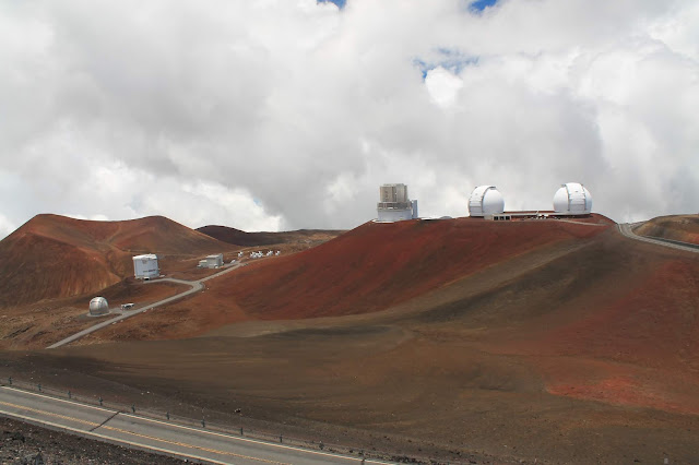
The big observatories are, from left to right, Canada-France-Hawaii, Gemini North, U. of Hawaii, J.C. Maxwell (blocky looking), Subaru (darkish top), Keck I and Keck II, and NASA infrared. Those reddish cinder cones are older than the higher, about 74,000 years old.
These cinder cones lie on the northeastern edge of the summit shield (the flatter area). The largest is called Mekanaka, and it is between 30,000 and 80,000 years old.
The observatories sit at quite different elevations, depending on which cinder cone they were built on.
Observatories above the clouds.
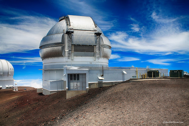
The Gemini North observatory is impressive.
Subaru, Keck I and II, and NASA infrared telescopes sit on top of cinder cones.
CalTech submillimeter, James Clark Maxwell, and the Submillimeter Array on Pu'u Poliahu cinder cone.
Mauna Loa through the clouds from Mauna Kea summit.
A bit farther down the road, I got this cloudy view of Mauna Loa.
Looking back up at the summit from a rest area. You can see the road carved into the slopes of the summit cinder cones.
From the same spot as the last picture, looking southward toward cloud-capped Mauna Loa.
From the lower ramp of the road, the visitor center and Mauna Loa.
Cinder cones near the visitor center date from around 70,000 years ago.
The visitor center, surrounded by cinder cones. Coming down off the impressive high peak, you'll have feelings of 1) repressurization, and 2) satisfaction that you have just had a once-in-a-lifetime experience. It's unique in all the world!
See also my Kilauea and Hawaii trips (click on key word Hawaii on the right side of the page).


