Switzerland: The Matterhorn
Explore the oceanic and continental crust that collided at one of the world's most scenic spots!
Who doesn't have the Matterhorn on their bucket list!? It was a dream of mine for years, and being there was more spectacular than I had ever imagined! Have a look at the mountain's incredible geology, and it will become much more than just a beautiful peak.
Travel to The Matterhorn
Interactive Google Map of the Matterhorn - Zermatt area
The Matterhorn is on the Switzerland - Italy border in the southwestern Alps. It's just south of Zermatt. The heart symbols are field trip locations that will be posted here in RocDocTravel.com.
Arrive by train from Tasch (upper right) to Zermatt (right-center). The Matterhorn is SW of Zermatt, and the Klein Matterhorn is east of it, at the heart symbol. The red lines are lifts and trams (!).

You'll find abundant information on trains, lodging, hiking & biking trails, trams, and skiing in books and by a simple web search.
My take on Switzerland: It's more expensive than all the countries around it, especially food and lodging, but the scenery and mountain accessibility are unmatched! Try Air B&B's or other private rentals for lodging. Staying in Zermatt is quite expensive, so we stayed in another town and drove to the train station in Tasch. Try eating out of grocery stores to save money and time. Driving in Switzerland is easy and even enjoyable, but speed limits are strictly enforced by merciless speed cameras. Do your homework and research, and you'll have an unforgettable trip of a lifetime!
Geology of the Matterhorn
Cross-section of the Matterhorn, from East to West. I think this explains the local geology better than any map or text. Source unknown. Appears on several websites without citation.
The Alps formed when the African plate collided with the European plate beginning at about 65 million years ago, as illustrated in the figure above. But it's not that simple! There was an ocean between the continents, complete with dark, dense oceanic crust & mantle lithosphere. The oceanic lithosphere (crust plus mantle) mostly subducted under Europe, but large chunks of it broke off and were thrust onto the European crust, and were in turn over-run by African crust.
One of the best places to see these over-thrust, sandwiched pieces of two continents and an oceanic crust is at Zermatt and the Matterhorn. The valley of Zermatt is a window down into the oceanic crust -- all the low slopes and Zermatt itself are oceanic crust, while the high peaks and ridges are African crust to the west and European crust to the east. [Technical note: I'm simplifying the names of the tectonic plates for general public consumption. Specialists use their own terms.]
The Matterhorn peak is African crust (granite) sitting on a slab of oceanic crust (all the dark rocks on the broad slopes to the north and east). Farther east, the oceanic crust sits on top of European crust (granite and related metamorphic rocks).
The suite of oceanic rocks is called ophiolite, and includes part of the mantle and all of the crust, including the old seafloor. Most of these rocks have been metamorphosed to varying degrees from place to place. They formed from the mid-Jurassic (about 170 million years ago, Ma) to the mid-Cretaceous (about 100 Ma), but were metamorphosed during continental collision after 65 Ma, buried, and ultimately uplifted to where we enjoy them now.
These places are on oceanic crust: Zermatt, Riffelhorn, Gornergrat, Klein Matterhorn, Glacier Paradise, Schwartzee -- everything south from Zermatt. Also NE from Zermatt, Allalinhorn and Saas Fee.
These places are African crust: Matterhorn, Tete Blanche, Dent Blanche, Ober Gabelhorn.
These are on European crust: Castor, Lyskam, Signalkuppe, Dufourspitze, Jagerhorn, and the town of Randa.
Zermatt
The main square in Zermatt, where you'll get off the train, will envelop you in Swiss charm. It's a good place to stock up on any food, drinks, or supplies you'll need during your day in the mountains.
To get to the mountain trams & lifts, you'll walk uphill through Zermatt. The streets are lined with touristy shops.
Take a few minutes to admire the square by Kirchstrasse with its beaver fountain.
After you've been on the mountain, visit the Matterhorn Museum for the history of Zermatt and mountaineering. It's to the left of this sign, below the beaver fountain.
Outside the Matterhorn Museum is this piece of oceanic crust. The rounded shapes are glass rinds on lava pillows, formed when basalt lava erupted on the ocean floor. It has been metamorphosed by deep burial during continental collision, but you can still see that it's pillow lava.
Behind the St. Mauritius church is the mountaineers' cemetery. This is the grave of the unknown climbers.
The Matterhorn
The 14,692 foot (4478 m) top of the Matterhorn is visible from a few spots in Zermatt. It's a thrill to see more and more of it come into view as you walk higher toward it! That must be a tremendous thrill for those trying to make its summit!
Like all Swiss mountain towns, Zermatt deals with frequent flash floods and seasonal high water. Each town has a wide, deep channel to handle the run-off. Switzerland is perhaps the best country in the world for flood and landslide mitigation (more on that later).
Take a good camera! The Matterhorn allows you to make your own postcards!
This view from higher on the mountain shows the dark oceanic rocks in the foreground, which contrast with the gray granite of the continental crust of the Matterhorn.
The Matterhorn's gray African crust stands high above the darker oceanic crust.
This view from near Schwartzee shows the dark oceanic rocks in the foreground. The plate boundary between continental and oceanic is at the base of the Matterhorn, in part covered by snow. The rocks of the peak were displaced tens of miles northward along this boundary.
Below the glaciers at Trockener Steg you'll see good exposures of ophiolite (oceanic mantle and crust).
Ophiolite cliffs below glaciers.
Looking down from the tram. These oceanic rocks were polished by movement of glaciers, which invariably have a blanket of rocks in their bottoms that act like sandpaper. Some of the oceanic crust was subducted as deep as 90 km during plate collision! It's one of Earth's most remarkable phenomena that plate tectonics has pushed rocks down that deep and then lifted them all the way back above the surface!
Glacier Paradise / Klein Matterhorn
The tram to Glacier Paradise is amazing! It has tremendously long spans between towers that swoop you down closer to the glaciers, then lift you up rapidly to the peak at 12,740 feet (3883 m). This is the highest publicly available tram in Switzerland (there is one higher near Chamonix in the French Alps).
The tram lets you off into a tunnel through the Klein Matterhorn peak.
The other (south) end of the tunnel lets you off on the edge of the Briethorn Plateau ice field, where you can ski year-round. This picture was taken in early September.

When you exit the tram tunnel, to your left (east) is a stunning view of the 13,662 foot (4164 m) Breithorn and its ever-growing snow cornice. See the climbers?

Here's a view back at the Klein Matterhorn and the tunnel you came out of. The bedrock is metamorphosed oceanic crust, originally gabbro. You can climb stairs to the peak at 12,740 feet, where signs show you the names of all the peaks and glaciers.

This close-up of the metamorphosed oceanic rocks on the peak. Originally basalt, gabbro, and peridotite, in places their original minerals have been replaced by their metamorphic equivalents.
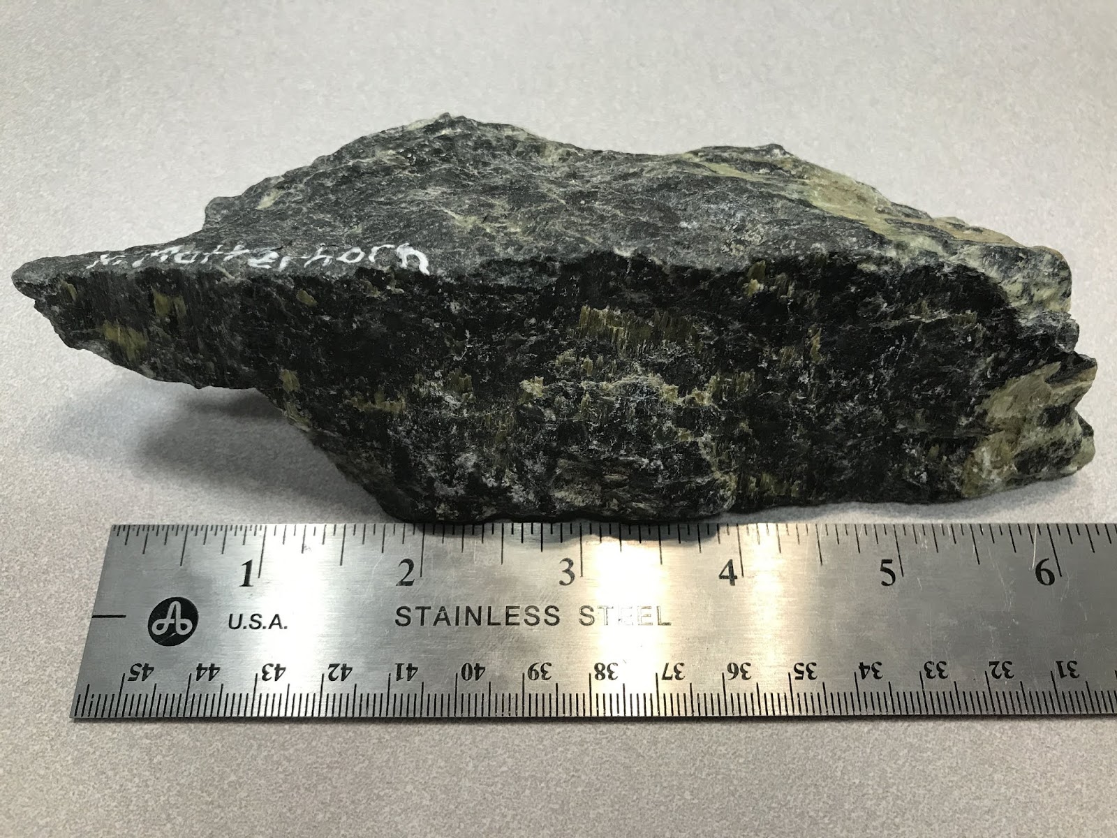
Here's a piece of metamorphosed oceanic crust (metabasalt) from the top of the Klein Matterhorn.
One of the signs at the summit of Klein Matterhorn, naming all the peaks and glaciers.
This high in the Alps, most of the slopes are covered in permanent ice or glaciers (it's only called a glacier if it moves, otherwise it's a snow field). See the ski lifts?
Looking down to the west at Testa Grigia, in Italy. Older snow and ice become covered by dust and rocks, giving much of it a gray cover.
Unfortunately when you visit the Matterhorn, you're at the mercy of the weather. Klein Matterhorn being directly east of the big peak, westerly winds as on this day obscured the Matterhorn in clouds.
It's called "Glacier Paradise" in part because of the tunnels into the ice. In the Klein Matterhorn peak is an elevator that takes you down to these tunnels.
More than any other, this place earns the appellation of "cool!" You can see the layers where the snow built up storm by storm, and has since been converted to ice under pressure.
Artists have done amazing work in the tunnels!
The Alps and Glaciers
It's amazing what you can see from Klein Matterhorn and the tram!
From the peak and the tram, you can see more than a dozen glaciers! The longest one to the east is Gornerglescher at about 7 miles (11 km), seen here at lower left with a large medial (center) moraine.
Where a glacier passes over a sudden drop in the valley underneath, fissures form. Note the dark oceanic crust here.
This ice jumble just east of the Klein Matterhorn shows what happens when ice passes over a cliff.
The flat bottom of Zermatt valley is a result of glaciers dragging away any & all loose rock. In the past ice ages, everything you see here was under ice. This view also shows the low treeline of the Alps, which is formed by a combination of temperature, moisture, latitude, and possibly past climate. Treeline in the U.S. Teton Range, for example, is nearly 10,000 feet (3048 m), but here in the Alps is only at 7200 feet (2200 m). Interestingly, no global explanation for treeline elevation has been agreed upon.
View to the northwest from the tram toward the peaks of Dent Blanch, Point du Zinal, Ober Gablehorn, and Wellenkuppe. The Matterhorn is off the left edge of the photo. The lower Theodulgletscher at lower right has a well-developed medial moraine, which forms where two glaciers merge. Rocks that fall off mountainsides onto the sides of glaciers are called lateral (meaning side) moraines. Where two lateral moraines combine where glaciers merge, they form medial moraines.
Looking north from the tram, you can see the late Ice Age level of glacial ice as the bare gray slopes on the side of the valley.
Related Posts:
Several other Switzerland posts!