Switzerland: Glarus Thrust
Switzerland's Glarus Thrust Fault
Explore one of the Alps' most significant geologic structures, a UNESCO World Heritage Site!
What is the Glarus Thrust?
The Alps formed when the European and African continents collided, beginning about 65 million years ago and continuing for most of the time since. In fact, the Alps are still moving very slowly northwestward toward Germany. Thrust faults are the major structures of that collision along with "nappes," which are huge tight folds with very long limbs. Most importantly for the Glarus thrust, Permian sedimentary rocks called the Verrucano group were shoved northward over 50 km over younger Cretaceous to Eocene rocks with various formation names.This thrust holds a significant place in the history of Geological science -- so much so, that it is a UNESCO World Heritage Site called "Swiss Tectonic Arena Sardona." It was one of the first places where a thrust fault was recognized, way back in the 1809 by Swiss engineer and statesman Hans Conrad Escher. He recognized that the rocks above the thrust are older than those below. It was epiphanies like this that eventually coalesced into today's understanding of Plate Tectonics, deformation of Earth's crust, and mountain-building. But at the time, it was such a radical idea that Escher and his son, geology professor at the École Polytechnique in Zürich, Arnold Escher, kept their interpretation quiet. It wasn't until more thrust faults were interpreted in the 1870's that eventually the idea was accepted in about 1900.
In the photos below, I'll show you why such an important discovery was made in this particular area.
Travel to the Glarus Thrust Fault
Interactive Google Map of the Glarus Thrust area near Flims and Laax, Switzerland.
Flights: Zurich is one of Europe's major airline hubs. Flights there are typically cheaper than other Swiss and southern German airports. You'll find similar prices to Milan, Italy, which isn't that far by train.
Trains: Plan on using Switzerland's amazing and comprehensive train system as much as you can! Trains go nearly everywhere, including to Laax.
Cars: Driving in the Alps is a treat for those who enjoy driving and have a decent car. It's what I recommend. On weekends, you'll see sports cars and sport bikes all over the twisting mountain pass roads. Caution: The main roads, especially in cities, have automatic speed cameras. You'll get a ticket if you're only a couple of mph over the limit, so be strictly obedient. Not true at most mountain passes.
Hotels: Laax/Flims is a marvelous resort area with lots of hotels and rentals, so you'll have an easy time finding accommodations.
Getting Up The Mountain: We obtained a permit to drive up the ski area. The roads are narrow and up higher are gravel, but they're quite passable for cars. If it's raining, it might get tricky. Check locally to find seasons & prices for lifts & trams. The Vorab glacier tram was not operating when we visited around Sept. 1st.
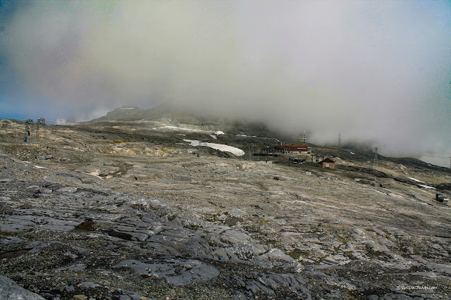
I'll show you the Glarus Thrust in its most convenient exposure -- at the top of the huge Flims - Laax ski area at Vorab glacier.
Here's a closer view of the upper ski area around Vorab glacier.
Geology of the Glarus Thrust

46.872657, 9.175017 If you have time to hike, the most spectacular cliff exposures of the thrust are at St. Martin's hole a few miles to the east, located here: 46.899607, 9.222605
This is Martinsloch, a hole where ice removed fractured bedrock just below the Glarus Thrust. The thrust is the ledge above. UNESCO picture.
Looking east up above the Vorab tram station, the thrust is the linear ledge across the peak. The foreground is Cretaceous Drusberg limestone that is full of fossils, and has been polished by glacial ice.
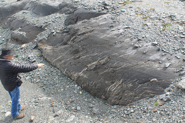
This Cretaceous limestone was plucked and polished smooth by the Vorab glacier. The bottom of a glacier is a rocky carpet frozen into the ice, so it scrapes and polishes everything it slides over.
Another look at the polished limestone.
The Cretaceous-age Drusberg limestone (more recently called the Tierwis Formation) is tilted to the west (left in this photo), and is abruptly chopped off by the thrust fault. The older Permian Verrucano rocks have been shoved northward by about 50 km, up and over the Drusberg.
So why were thrust faults first recognized here? It has just the right elements -- rock layers of known age (dated relatively by their fossils), distinctly different rock types, truncation of the lower layers, excellent exposures, and a highly polished fault surface that any scientist can't help but ask questions about.
When a scientist looks at an outcrop like this, questions immediately arise. Why are the lower layers tilted and truncated? Why are the rocks above wavy, with small folds all through them? Why is the surface so planar and polished? It was known in the early 1800's from regional geology that the Verrucano rocks (the darker ones above the fault) are normally below the Cretaceous limestones, and so this outcrop immediately raised the question of why the Verrucano is on top here.
Early explanations tried to avoid the radical idea of long-distance transport by thrust faults (remember, they viewed Earth as static, not mobile), invoking untenable ideas like huge overturned folds. But the Eschers kept their interpretation of thrust faulting alive, and it was eventually accepted.

That's the fault! For having 50 km of displacement, the rocks are surprisingly deformed in only a very thin layer.
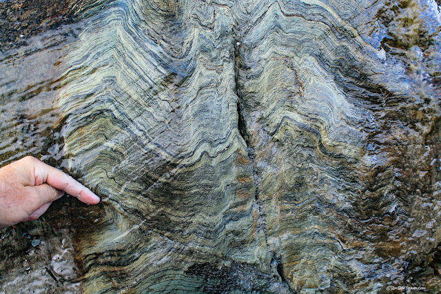
Small folds are common in the Verrucano, as are small faults like the one my finger is pointing to. This surface was polished by the side of the glacier.
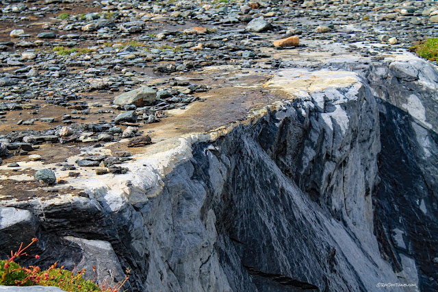
Crushing of rock along the fault created a texture called mylonite, which means the minerals have been crushed and sheared to an extremely small size. Mylonite resists erosion, so that it forms this dance-floor-flat ledge. Because it is made of limestone, which is unusual, it's called a carbonate mylonite, or calc-mylonite.
The top of the Cretaceous limestone is chopped off cleanly along the fault. The mylonite is in these rocks.
Close-up, you can see the mylonite layering. Remarkably, all that shearing only affected a few centimeters of rock. Microscopic and geochemical studies suggest that large amounts of water flowed through this zone during faulting.
Mylonite cap on the Cretaceous limestone.
Wavy Permian Verrucano rocks above the tilted, chopped-off Cretaceous limestone.
The Cretaceous limestone has several smaller faults in it, represented by these parallel ledges. Slivers of rock slid over and under each other during thrust faulting, with the Verrucano sliding over them all.
Looking southward downhill, the glaciated Cretaceous limestone is in the foreground.
The thrust is also exposed in the peak above the Vorab tram station.
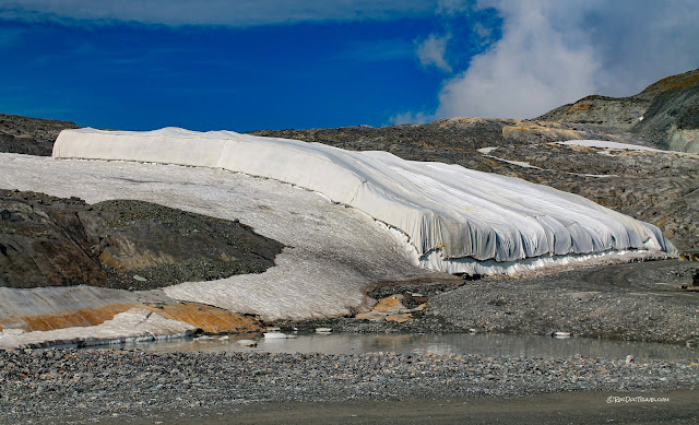
Here's one of the glacier blankets designed to preserve snow through the summer to provide water to the streams.
Looking back up at the Glarus thrust outcrop.
Here's another view of the thrust a bit farther west, still at the top of the ski area. The light colored Cretaceous limestones are identified here as the Schrattenkalk, and the lower darker ones are the Drusberg.
The view southward over Flims.
For those who may be wondering at this point, the treeline is quite low in the Alps compared to in the U.S. It's only around 7000 feet here, compared to near 10,000 feet in the western U.S. The treeline is determined by climate, which is more severe in the Alps.
In another field trip, we'll visit the Flims landslide, one of Earth's biggest. The jumbled looking rocks in the middle of this picture are in the top of the landslide.
Related Field Trips: Key word Switzerland


